You are here: Home > Network List > GT - Global Telemetered Seismograph Network (USAF/USGS) Stations List
> Station PLCA Paso Flores, Argentina > Earthquake Result Viewer
PLCA Paso Flores, Argentina - Earthquake Result Viewer
| Earthquake location: |
South Sandwich Islands Region |
| Earthquake latitude/longitude: |
-60.2/-26.5 |
| Earthquake time(UTC): |
2019/08/27 (239) 23:55:18 GMT |
| Earthquake Depth: |
10 km |
| Earthquake Magnitude: |
6.6 mww |
| Earthquake Catalog/Contributor: |
NEIC PDE/us |
|
| Network: |
GT Global Telemetered Seismograph Network (USAF/USGS) |
| Station: |
PLCA Paso Flores, Argentina |
| Lat/Lon: |
40.73 S/70.55 W |
| Elevation: |
1050 m |
|
| Distance: |
33.3 deg |
| Az: |
285.76 deg |
| Baz: |
140.789 deg |
| Ray Param: |
0.07828098 |
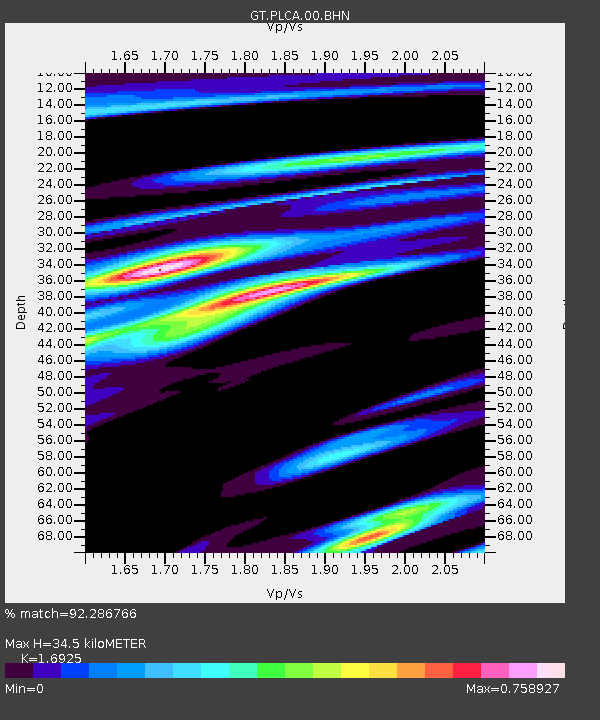
| Estimated Moho Depth: |
34.5 km |
| Estimated Crust Vp/Vs: |
1.69 |
| Assumed Crust Vp: |
6.597 km/s |
| Estimated Crust Vs: |
3.898 km/s |
| Estimated Crust Poisson's Ratio: |
0.23 |
|
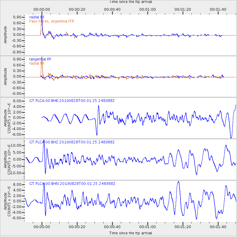
| Radial Match: |
92.286766 % |
| Radial Bump: |
326 |
| Transverse Match: |
61.94547 % |
| Transverse Bump: |
400 |
| SOD ConfigId: |
19053131 |
| Insert Time: |
2019-09-10 23:59:05.311 +0000 |
| GWidth: |
2.5 |
| Max Bumps: |
400 |
| Tol: |
0.001 |
|
Signal To Noise
| Channel | StoN | STA | LTA |
| GT:PLCA:00:BHZ:20190828T00:01:25.248988Z | 5.470333 | 6.333644E-6 | 1.1578169E-6 |
| GT:PLCA:00:BHN:20190828T00:01:25.248988Z | 2.6434276 | 2.917005E-6 | 1.1034934E-6 |
| GT:PLCA:00:BHE:20190828T00:01:25.248988Z | 2.5535758 | 2.5661689E-6 | 1.0049316E-6 |
| Arrivals |
| Ps | 4.0 SECOND |
| PpPs | 13 SECOND |
| PsPs/PpSs | 17 SECOND |


