You are here: Home > Network List > II - Global Seismograph Network (GSN - IRIS/IDA) Stations List
> Station ABPO Ambohimpanompo, Madagascar > Earthquake Result Viewer
ABPO Ambohimpanompo, Madagascar - Earthquake Result Viewer
| Earthquake location: |
South Sandwich Islands Region |
| Earthquake latitude/longitude: |
-60.2/-26.5 |
| Earthquake time(UTC): |
2019/08/27 (239) 23:55:18 GMT |
| Earthquake Depth: |
10 km |
| Earthquake Magnitude: |
6.6 mww |
| Earthquake Catalog/Contributor: |
NEIC PDE/us |
|
| Network: |
II Global Seismograph Network (GSN - IRIS/IDA) |
| Station: |
ABPO Ambohimpanompo, Madagascar |
| Lat/Lon: |
19.02 S/47.23 E |
| Elevation: |
1528 m |
|
| Distance: |
65.6 deg |
| Az: |
85.745 deg |
| Baz: |
211.747 deg |
| Ray Param: |
0.058150817 |
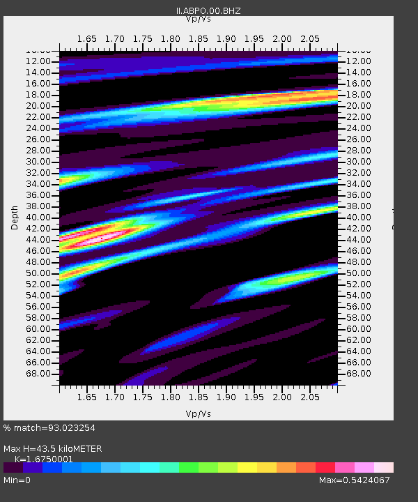
| Estimated Moho Depth: |
43.5 km |
| Estimated Crust Vp/Vs: |
1.68 |
| Assumed Crust Vp: |
6.642 km/s |
| Estimated Crust Vs: |
3.965 km/s |
| Estimated Crust Poisson's Ratio: |
0.22 |
|
| Radial Match: |
93.023254 % |
| Radial Bump: |
400 |
| Transverse Match: |
78.92834 % |
| Transverse Bump: |
400 |
| SOD ConfigId: |
19053131 |
| Insert Time: |
2019-09-10 23:59:05.833 +0000 |
| GWidth: |
2.5 |
| Max Bumps: |
400 |
| Tol: |
0.001 |
|
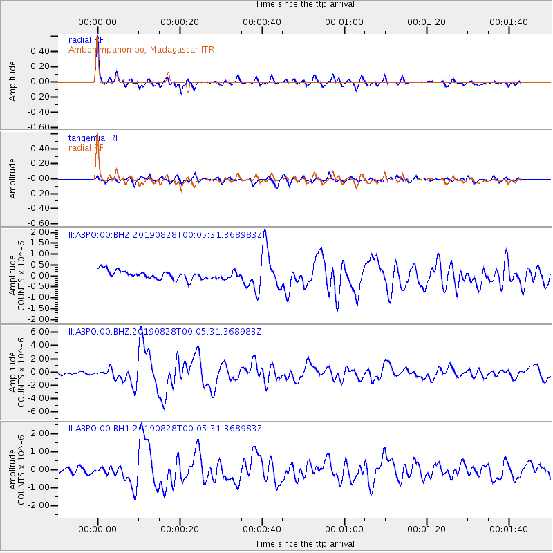
Signal To Noise
| Channel | StoN | STA | LTA |
| II:ABPO:00:BHZ:20190828T00:05:31.368983Z | 3.9667227 | 5.8718496E-7 | 1.4802774E-7 |
| II:ABPO:00:BH1:20190828T00:05:31.368983Z | 0.8572772 | 1.4924208E-7 | 1.7408847E-7 |
| II:ABPO:00:BH2:20190828T00:05:31.368983Z | 0.8622085 | 1.6576799E-7 | 1.9225975E-7 |
| Arrivals |
| Ps | 4.6 SECOND |
| PpPs | 17 SECOND |
| PsPs/PpSs | 21 SECOND |


