You are here: Home > Network List > II - Global Seismograph Network (GSN - IRIS/IDA) Stations List
> Station WRAB Tennant Creek, NT, Australia > Earthquake Result Viewer
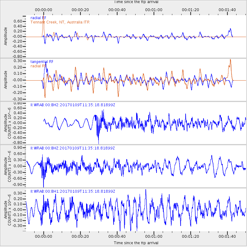
WRAB Tennant Creek, NT, Australia - Earthquake Result Viewer
*The percent match for this event was below the threshold and hence no stack was calculated.
| Earthquake location: |
Southern Sumatra, Indonesia |
| Earthquake latitude/longitude: |
-1.6/100.3 |
| Earthquake time(UTC): |
2017/01/09 (009) 11:28:38 GMT |
| Earthquake Depth: |
64 km |
| Earthquake Magnitude: |
5.5 mb |
| Earthquake Catalog/Contributor: |
NEIC PDE/us |
|
| Network: |
II Global Seismograph Network (GSN - IRIS/IDA) |
| Station: |
WRAB Tennant Creek, NT, Australia |
| Lat/Lon: |
19.93 S/134.36 E |
| Elevation: |
366 m |
|
| Distance: |
37.9 deg |
| Az: |
121.024 deg |
| Baz: |
294.428 deg |
| Ray Param: |
$rayparam |
*The percent match for this event was below the threshold and hence was not used in the summary stack. |
|
| Radial Match: |
51.136234 % |
| Radial Bump: |
400 |
| Transverse Match: |
54.439114 % |
| Transverse Bump: |
400 |
| SOD ConfigId: |
1943534 |
| Insert Time: |
2017-01-23 11:29:26.859 +0000 |
| GWidth: |
2.5 |
| Max Bumps: |
400 |
| Tol: |
0.001 |
|
Signal To Noise
| Channel | StoN | STA | LTA |
| II:WRAB:00:BHZ:20170109T11:35:18.81899Z | 2.1130414 | 3.073099E-7 | 1.4543487E-7 |
| II:WRAB:00:BH1:20170109T11:35:18.81899Z | 1.2778141 | 1.3732743E-7 | 1.0747058E-7 |
| II:WRAB:00:BH2:20170109T11:35:18.81899Z | 2.1896973 | 2.7445301E-7 | 1.2533835E-7 |
| Arrivals |
| Ps | |
| PpPs | |
| PsPs/PpSs | |


