You are here: Home > Network List > BL - Brazilian Lithospheric Seismic Project (BLSP) Stations List
> Station PMNB Patos de Minas, MG > Earthquake Result Viewer
PMNB Patos de Minas, MG - Earthquake Result Viewer
| Earthquake location: |
South Sandwich Islands Region |
| Earthquake latitude/longitude: |
-60.3/-26.8 |
| Earthquake time(UTC): |
2019/08/27 (239) 23:55:30 GMT |
| Earthquake Depth: |
116 km |
| Earthquake Magnitude: |
6.8 Mi |
| Earthquake Catalog/Contributor: |
NEIC PDE/at |
|
| Network: |
BL Brazilian Lithospheric Seismic Project (BLSP) |
| Station: |
PMNB Patos de Minas, MG |
| Lat/Lon: |
18.54 S/46.44 W |
| Elevation: |
950 m |
|
| Distance: |
44.0 deg |
| Az: |
332.688 deg |
| Baz: |
166.064 deg |
| Ray Param: |
0.071774416 |
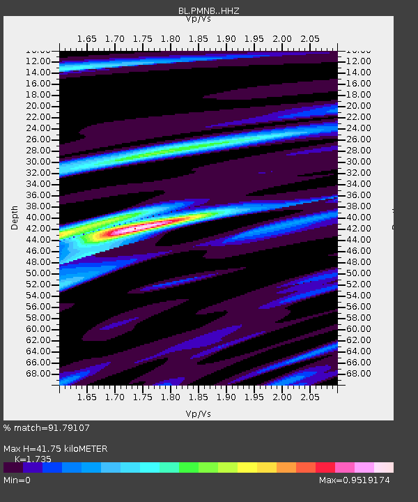
| Estimated Moho Depth: |
41.75 km |
| Estimated Crust Vp/Vs: |
1.74 |
| Assumed Crust Vp: |
6.419 km/s |
| Estimated Crust Vs: |
3.7 km/s |
| Estimated Crust Poisson's Ratio: |
0.25 |
|
| Radial Match: |
91.79107 % |
| Radial Bump: |
268 |
| Transverse Match: |
66.95235 % |
| Transverse Bump: |
400 |
| SOD ConfigId: |
19053131 |
| Insert Time: |
2019-09-11 00:00:43.495 +0000 |
| GWidth: |
2.5 |
| Max Bumps: |
400 |
| Tol: |
0.001 |
|

Signal To Noise
| Channel | StoN | STA | LTA |
| BL:PMNB: :HHZ:20190828T00:02:55.619995Z | 13.379742 | 3.224295E-6 | 2.4098335E-7 |
| BL:PMNB: :HHN:20190828T00:02:55.619995Z | 8.687043 | 2.189466E-6 | 2.520381E-7 |
| BL:PMNB: :HHE:20190828T00:02:55.619995Z | 3.2431138 | 5.9881825E-7 | 1.8464299E-7 |
| Arrivals |
| Ps | 5.1 SECOND |
| PpPs | 17 SECOND |
| PsPs/PpSs | 22 SECOND |


