You are here: Home > Network List > C - Chilean National Seismic Network Stations List
> Station GO06 Curarrehue (Paso Mamuil Malal), Chile > Earthquake Result Viewer
GO06 Curarrehue (Paso Mamuil Malal), Chile - Earthquake Result Viewer
| Earthquake location: |
South Sandwich Islands Region |
| Earthquake latitude/longitude: |
-60.3/-26.8 |
| Earthquake time(UTC): |
2019/08/27 (239) 23:55:30 GMT |
| Earthquake Depth: |
116 km |
| Earthquake Magnitude: |
6.8 Mi |
| Earthquake Catalog/Contributor: |
NEIC PDE/at |
|
| Network: |
C Chilean National Seismic Network |
| Station: |
GO06 Curarrehue (Paso Mamuil Malal), Chile |
| Lat/Lon: |
39.58 S/71.47 W |
| Elevation: |
1250 m |
|
| Distance: |
34.5 deg |
| Az: |
286.461 deg |
| Baz: |
141.832 deg |
| Ray Param: |
0.07733195 |
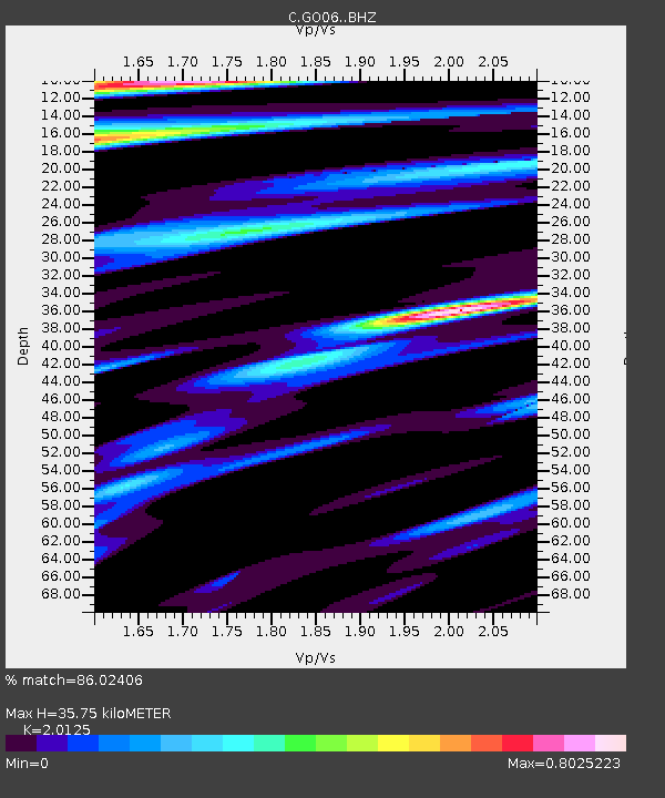
| Estimated Moho Depth: |
35.75 km |
| Estimated Crust Vp/Vs: |
2.01 |
| Assumed Crust Vp: |
6.597 km/s |
| Estimated Crust Vs: |
3.278 km/s |
| Estimated Crust Poisson's Ratio: |
0.34 |
|
| Radial Match: |
86.02406 % |
| Radial Bump: |
400 |
| Transverse Match: |
60.85813 % |
| Transverse Bump: |
400 |
| SOD ConfigId: |
19053131 |
| Insert Time: |
2019-09-11 00:00:53.860 +0000 |
| GWidth: |
2.5 |
| Max Bumps: |
400 |
| Tol: |
0.001 |
|

Signal To Noise
| Channel | StoN | STA | LTA |
| C:GO06: :BHZ:20190828T00:01:36.748993Z | 9.728121 | 4.6324303E-6 | 4.7618963E-7 |
| C:GO06: :BHN:20190828T00:01:36.748993Z | 4.725726 | 1.9923425E-6 | 4.2159502E-7 |
| C:GO06: :BHE:20190828T00:01:36.748993Z | 3.4697063 | 1.9121285E-6 | 5.5109234E-7 |
| Arrivals |
| Ps | 5.9 SECOND |
| PpPs | 15 SECOND |
| PsPs/PpSs | 21 SECOND |


