You are here: Home > Network List > C1 - Red Sismologica Nacional Stations List
> Station MT02 Curacavi > Earthquake Result Viewer
MT02 Curacavi - Earthquake Result Viewer
| Earthquake location: |
South Sandwich Islands Region |
| Earthquake latitude/longitude: |
-60.3/-26.8 |
| Earthquake time(UTC): |
2019/08/27 (239) 23:55:30 GMT |
| Earthquake Depth: |
116 km |
| Earthquake Magnitude: |
6.8 Mi |
| Earthquake Catalog/Contributor: |
NEIC PDE/at |
|
| Network: |
C1 Red Sismologica Nacional |
| Station: |
MT02 Curacavi |
| Lat/Lon: |
33.26 S/71.14 W |
| Elevation: |
338 m |
|
| Distance: |
39.5 deg |
| Az: |
292.943 deg |
| Baz: |
146.817 deg |
| Ray Param: |
0.07454749 |
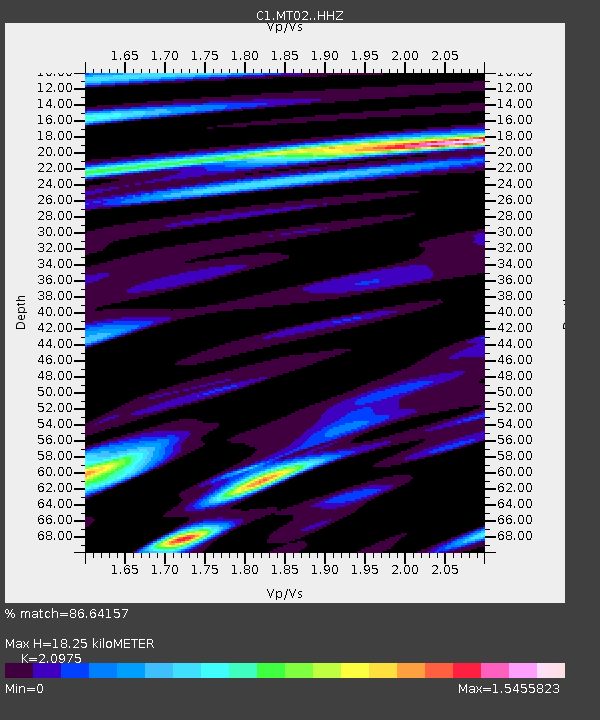
| Estimated Moho Depth: |
18.25 km |
| Estimated Crust Vp/Vs: |
2.10 |
| Assumed Crust Vp: |
6.481 km/s |
| Estimated Crust Vs: |
3.09 km/s |
| Estimated Crust Poisson's Ratio: |
0.35 |
|
| Radial Match: |
86.64157 % |
| Radial Bump: |
400 |
| Transverse Match: |
88.60736 % |
| Transverse Bump: |
400 |
| SOD ConfigId: |
19053131 |
| Insert Time: |
2019-09-11 00:01:11.404 +0000 |
| GWidth: |
2.5 |
| Max Bumps: |
400 |
| Tol: |
0.001 |
|

Signal To Noise
| Channel | StoN | STA | LTA |
| C1:MT02: :HHZ:20190828T00:02:18.73999Z | 81.17225 | 1.7039387E-5 | 2.0991641E-7 |
| C1:MT02: :HHN:20190828T00:02:18.73999Z | 16.156883 | 7.123526E-6 | 4.4089725E-7 |
| C1:MT02: :HHE:20190828T00:02:18.73999Z | 23.232597 | 7.281916E-6 | 3.1343532E-7 |
| Arrivals |
| Ps | 3.3 SECOND |
| PpPs | 8.2 SECOND |
| PsPs/PpSs | 11 SECOND |


