You are here: Home > Network List > TS - TERRAscope (Southern California Seismic Network) Stations List
> Station MLAC Mammoth Lakes, California, USA > Earthquake Result Viewer
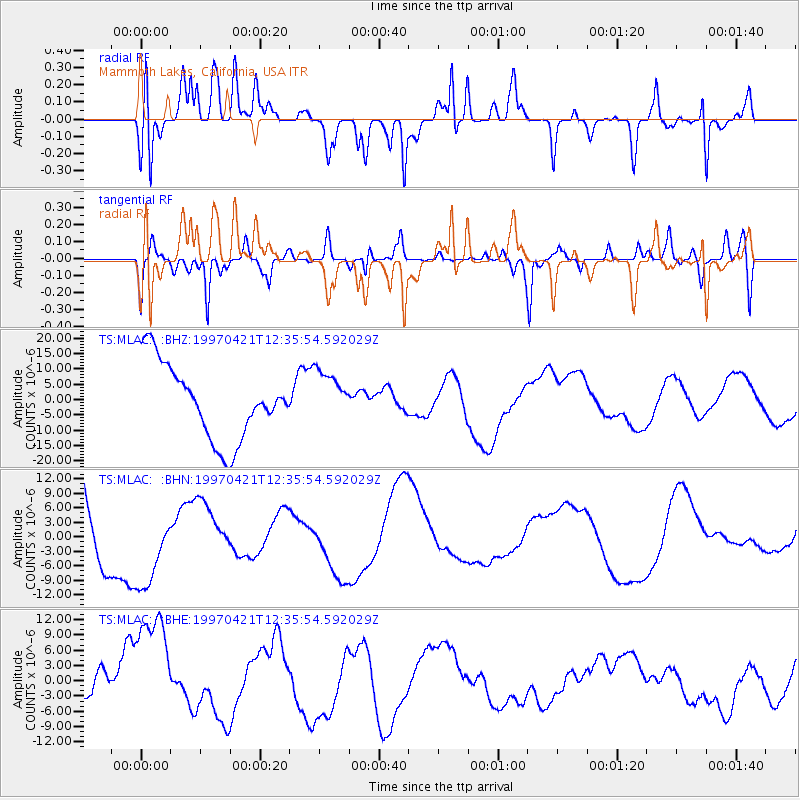
MLAC Mammoth Lakes, California, USA - Earthquake Result Viewer
*The percent match for this event was below the threshold and hence no stack was calculated.
| Earthquake location: |
Vanuatu Islands |
| Earthquake latitude/longitude: |
-13.7/166.5 |
| Earthquake time(UTC): |
1997/04/21 (111) 12:23:46 GMT |
| Earthquake Depth: |
33 km |
| Earthquake Magnitude: |
5.5 MB |
| Earthquake Catalog/Contributor: |
WHDF/NEIC |
|
| Network: |
TS TERRAscope (Southern California Seismic Network) |
| Station: |
MLAC Mammoth Lakes, California, USA |
| Lat/Lon: |
37.63 N/118.83 W |
| Elevation: |
2170 m |
|
| Distance: |
86.5 deg |
| Az: |
50.108 deg |
| Baz: |
249.943 deg |
| Ray Param: |
$rayparam |
*The percent match for this event was below the threshold and hence was not used in the summary stack. |
|
| Radial Match: |
55.129738 % |
| Radial Bump: |
391 |
| Transverse Match: |
54.90383 % |
| Transverse Bump: |
400 |
| SOD ConfigId: |
4480 |
| Insert Time: |
2010-02-26 14:27:03.599 +0000 |
| GWidth: |
2.5 |
| Max Bumps: |
400 |
| Tol: |
0.001 |
|
Signal To Noise
| Channel | StoN | STA | LTA |
| TS:MLAC: :BHN:19970421T12:35:54.592029Z | 0.7697692 | 8.243797E-6 | 1.070944E-5 |
| TS:MLAC: :BHE:19970421T12:35:54.592029Z | 1.8648082 | 1.1917933E-5 | 6.39097E-6 |
| TS:MLAC: :BHZ:19970421T12:35:54.592029Z | 0.70827174 | 8.626139E-6 | 1.2179137E-5 |
| Arrivals |
| Ps | |
| PpPs | |
| PsPs/PpSs | |


