You are here: Home > Network List > G - GEOSCOPE Stations List
> Station TAM Tamanrasset, Algeria > Earthquake Result Viewer
TAM Tamanrasset, Algeria - Earthquake Result Viewer
| Earthquake location: |
South Sandwich Islands Region |
| Earthquake latitude/longitude: |
-60.3/-26.8 |
| Earthquake time(UTC): |
2019/08/27 (239) 23:55:30 GMT |
| Earthquake Depth: |
116 km |
| Earthquake Magnitude: |
6.8 Mi |
| Earthquake Catalog/Contributor: |
NEIC PDE/at |
|
| Network: |
G GEOSCOPE |
| Station: |
TAM Tamanrasset, Algeria |
| Lat/Lon: |
22.79 N/5.53 E |
| Elevation: |
1377 m |
|
| Distance: |
86.9 deg |
| Az: |
29.619 deg |
| Baz: |
195.467 deg |
| Ray Param: |
0.043473415 |
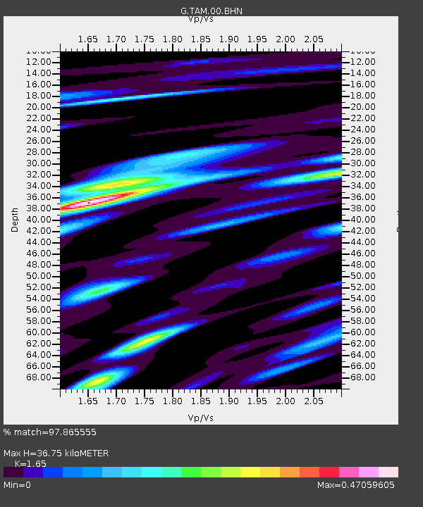
| Estimated Moho Depth: |
36.75 km |
| Estimated Crust Vp/Vs: |
1.65 |
| Assumed Crust Vp: |
6.61 km/s |
| Estimated Crust Vs: |
4.006 km/s |
| Estimated Crust Poisson's Ratio: |
0.21 |
|
| Radial Match: |
97.865555 % |
| Radial Bump: |
400 |
| Transverse Match: |
92.7474 % |
| Transverse Bump: |
400 |
| SOD ConfigId: |
19053131 |
| Insert Time: |
2019-09-11 00:01:40.428 +0000 |
| GWidth: |
2.5 |
| Max Bumps: |
400 |
| Tol: |
0.001 |
|
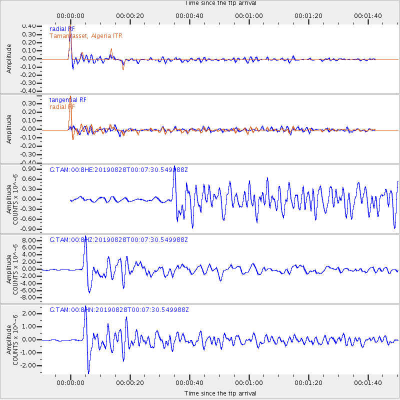
Signal To Noise
| Channel | StoN | STA | LTA |
| G:TAM:00:BHZ:20190828T00:07:30.549988Z | 21.799774 | 1.8602622E-6 | 8.533401E-8 |
| G:TAM:00:BHN:20190828T00:07:30.549988Z | 13.382451 | 4.7304087E-7 | 3.534785E-8 |
| G:TAM:00:BHE:20190828T00:07:30.549988Z | 4.398077 | 1.9973214E-7 | 4.541352E-8 |
| Arrivals |
| Ps | 3.7 SECOND |
| PpPs | 14 SECOND |
| PsPs/PpSs | 18 SECOND |


