You are here: Home > Network List > II - Global Seismograph Network (GSN - IRIS/IDA) Stations List
> Station ABPO Ambohimpanompo, Madagascar > Earthquake Result Viewer
ABPO Ambohimpanompo, Madagascar - Earthquake Result Viewer

| Earthquake location: |
South Sandwich Islands Region |
| Earthquake latitude/longitude: |
-60.3/-26.8 |
| Earthquake time(UTC): |
2019/08/27 (239) 23:55:30 GMT |
| Earthquake Depth: |
116 km |
| Earthquake Magnitude: |
6.8 Mi |
| Earthquake Catalog/Contributor: |
NEIC PDE/at |
|
| Network: |
II Global Seismograph Network (GSN - IRIS/IDA) |
| Station: |
ABPO Ambohimpanompo, Madagascar |
| Lat/Lon: |
19.02 S/47.23 E |
| Elevation: |
1528 m |
|
| Distance: |
65.8 deg |
| Az: |
85.947 deg |
| Baz: |
211.67 deg |
| Ray Param: |
0.057744555 |
| Estimated Moho Depth: |
43.5 km |
| Estimated Crust Vp/Vs: |
1.68 |
| Assumed Crust Vp: |
6.642 km/s |
| Estimated Crust Vs: |
3.959 km/s |
| Estimated Crust Poisson's Ratio: |
0.22 |
|
| Radial Match: |
92.99738 % |
| Radial Bump: |
400 |
| Transverse Match: |
78.66752 % |
| Transverse Bump: |
400 |
| SOD ConfigId: |
19053131 |
| Insert Time: |
2019-09-11 00:01:52.158 +0000 |
| GWidth: |
2.5 |
| Max Bumps: |
400 |
| Tol: |
0.001 |
|
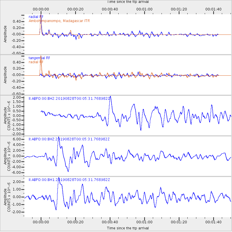
Signal To Noise
| Channel | StoN | STA | LTA |
| II:ABPO:00:BHZ:20190828T00:05:31.768982Z | 4.0394573 | 5.9840715E-7 | 1.4814049E-7 |
| II:ABPO:00:BH1:20190828T00:05:31.768982Z | 0.8825445 | 1.5514412E-7 | 1.7579185E-7 |
| II:ABPO:00:BH2:20190828T00:05:31.768982Z | 0.8359863 | 1.6225357E-7 | 1.940864E-7 |
| Arrivals |
| Ps | 4.6 SECOND |
| PpPs | 17 SECOND |
| PsPs/PpSs | 21 SECOND |


