You are here: Home > Network List > TS - TERRAscope (Southern California Seismic Network) Stations List
> Station MLAC Mammoth Lakes, California, USA > Earthquake Result Viewer
MLAC Mammoth Lakes, California, USA - Earthquake Result Viewer
*The percent match for this event was below the threshold and hence no stack was calculated.
| Earthquake location: |
Leeward Islands |
| Earthquake latitude/longitude: |
16.6/-59.6 |
| Earthquake time(UTC): |
1995/03/08 (067) 03:45:59 GMT |
| Earthquake Depth: |
15 km |
| Earthquake Magnitude: |
6.3 MB, 6.2 MS, 6.4 UNKNOWN, 6.1 MD |
| Earthquake Catalog/Contributor: |
WHDF/NEIC |
|
| Network: |
TS TERRAscope (Southern California Seismic Network) |
| Station: |
MLAC Mammoth Lakes, California, USA |
| Lat/Lon: |
37.63 N/118.83 W |
| Elevation: |
2170 m |
|
| Distance: |
55.8 deg |
| Az: |
304.455 deg |
| Baz: |
95.076 deg |
| Ray Param: |
$rayparam |
*The percent match for this event was below the threshold and hence was not used in the summary stack. |
|
| Radial Match: |
81.50395 % |
| Radial Bump: |
400 |
| Transverse Match: |
67.519104 % |
| Transverse Bump: |
400 |
| SOD ConfigId: |
4480 |
| Insert Time: |
2010-02-26 14:27:04.212 +0000 |
| GWidth: |
2.5 |
| Max Bumps: |
400 |
| Tol: |
0.001 |
|
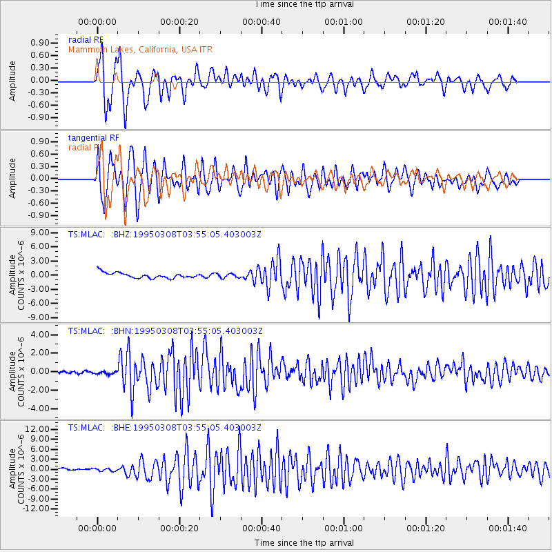
Signal To Noise
| Channel | StoN | STA | LTA |
| TS:MLAC: :BHN:19950308T03:55:05.403003Z | 0.61181045 | 1.4300164E-7 | 2.3373522E-7 |
| TS:MLAC: :BHE:19950308T03:55:05.403003Z | 0.7973998 | 5.4025105E-7 | 6.775159E-7 |
| TS:MLAC: :BHZ:19950308T03:55:05.403003Z | 0.73102844 | 4.1887841E-7 | 5.729988E-7 |
| Arrivals |
| Ps | |
| PpPs | |
| PsPs/PpSs | |


