You are here: Home > Network List > G - GEOSCOPE Stations List
> Station CRZF Port Alfred, Crozet, South Indian Ocean > Earthquake Result Viewer
CRZF Port Alfred, Crozet, South Indian Ocean - Earthquake Result Viewer
| Earthquake location: |
Celebes Sea |
| Earthquake latitude/longitude: |
4.4/122.7 |
| Earthquake time(UTC): |
2017/01/10 (010) 06:13:48 GMT |
| Earthquake Depth: |
622 km |
| Earthquake Magnitude: |
6.9 Mi |
| Earthquake Catalog/Contributor: |
NEIC PDE/at |
|
| Network: |
G GEOSCOPE |
| Station: |
CRZF Port Alfred, Crozet, South Indian Ocean |
| Lat/Lon: |
46.43 S/51.86 E |
| Elevation: |
140 m |
|
| Distance: |
80.2 deg |
| Az: |
221.54 deg |
| Baz: |
72.931 deg |
| Ray Param: |
0.0465279 |
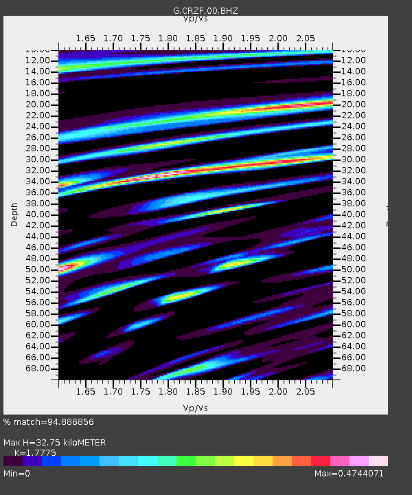
| Estimated Moho Depth: |
32.75 km |
| Estimated Crust Vp/Vs: |
1.78 |
| Assumed Crust Vp: |
4.802 km/s |
| Estimated Crust Vs: |
2.702 km/s |
| Estimated Crust Poisson's Ratio: |
0.27 |
|
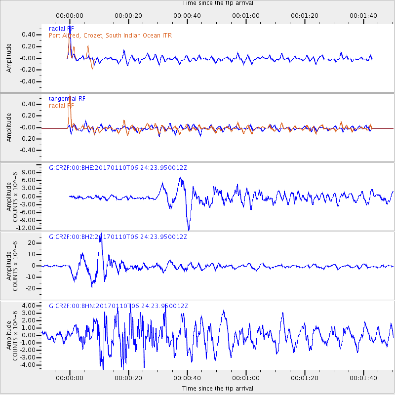
| Radial Match: |
94.886856 % |
| Radial Bump: |
340 |
| Transverse Match: |
88.98415 % |
| Transverse Bump: |
400 |
| SOD ConfigId: |
1943534 |
| Insert Time: |
2017-01-24 06:20:30.227 +0000 |
| GWidth: |
2.5 |
| Max Bumps: |
400 |
| Tol: |
0.001 |
|
Signal To Noise
| Channel | StoN | STA | LTA |
| G:CRZF:00:BHZ:20170110T06:24:23.950012Z | 22.06282 | 7.1531013E-6 | 3.2421516E-7 |
| G:CRZF:00:BHN:20170110T06:24:23.950012Z | 1.8427639 | 8.486732E-7 | 4.6054367E-7 |
| G:CRZF:00:BHE:20170110T06:24:23.950012Z | 6.661082 | 2.7944511E-6 | 4.1951913E-7 |
| Arrivals |
| Ps | 5.4 SECOND |
| PpPs | 19 SECOND |
| PsPs/PpSs | 24 SECOND |


