You are here: Home > Network List > TA - USArray Transportable Network (new EarthScope stations) Stations List
> Station G10A Bishop Fram, Joseph, OR, USA > Earthquake Result Viewer
G10A Bishop Fram, Joseph, OR, USA - Earthquake Result Viewer
| Earthquake location: |
Windward Islands |
| Earthquake latitude/longitude: |
15.0/-61.3 |
| Earthquake time(UTC): |
2007/11/29 (333) 19:00:19 GMT |
| Earthquake Depth: |
148 km |
| Earthquake Magnitude: |
6.9 MB, 7.4 MW, 7.4 MW |
| Earthquake Catalog/Contributor: |
WHDF/NEIC |
|
| Network: |
TA USArray Transportable Network (new EarthScope stations) |
| Station: |
G10A Bishop Fram, Joseph, OR, USA |
| Lat/Lon: |
45.29 N/117.12 W |
| Elevation: |
1527 m |
|
| Distance: |
55.6 deg |
| Az: |
314.935 deg |
| Baz: |
104.24 deg |
| Ray Param: |
0.06420185 |
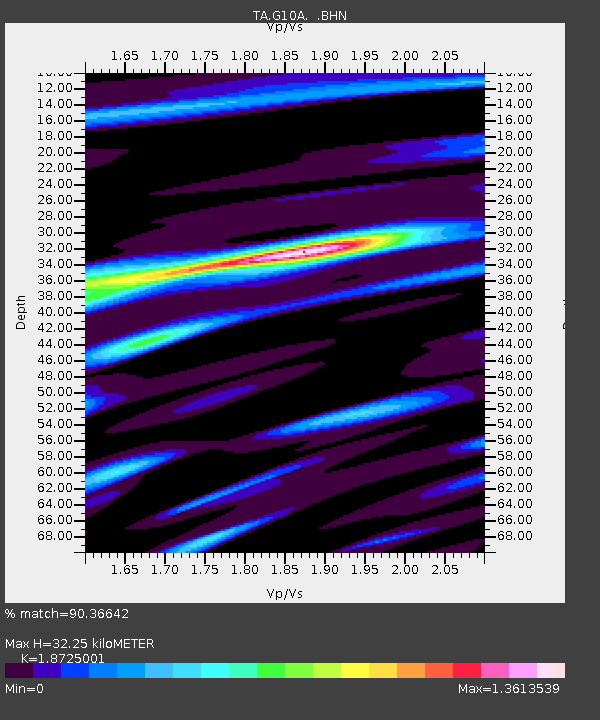
| Estimated Moho Depth: |
32.25 km |
| Estimated Crust Vp/Vs: |
1.87 |
| Assumed Crust Vp: |
6.571 km/s |
| Estimated Crust Vs: |
3.509 km/s |
| Estimated Crust Poisson's Ratio: |
0.30 |
|
| Radial Match: |
90.36642 % |
| Radial Bump: |
400 |
| Transverse Match: |
82.16492 % |
| Transverse Bump: |
400 |
| SOD ConfigId: |
2564 |
| Insert Time: |
2010-03-07 03:43:24.887 +0000 |
| GWidth: |
2.5 |
| Max Bumps: |
400 |
| Tol: |
0.001 |
|

Signal To Noise
| Channel | StoN | STA | LTA |
| TA:G10A: :BHN:20071129T19:09:09.425024Z | 2.135919 | 6.7800204E-7 | 3.1742871E-7 |
| TA:G10A: :BHE:20071129T19:09:09.425024Z | 11.5023365 | 3.755184E-6 | 3.264714E-7 |
| TA:G10A: :BHZ:20071129T19:09:09.425024Z | 21.187544 | 6.9669018E-6 | 3.2882065E-7 |
| Arrivals |
| Ps | 4.5 SECOND |
| PpPs | 13 SECOND |
| PsPs/PpSs | 18 SECOND |


