You are here: Home > Network List > G - GEOSCOPE Stations List
> Station NOUC Port Laguerre, New Caledonia > Earthquake Result Viewer
NOUC Port Laguerre, New Caledonia - Earthquake Result Viewer
| Earthquake location: |
Celebes Sea |
| Earthquake latitude/longitude: |
4.4/122.7 |
| Earthquake time(UTC): |
2017/01/10 (010) 06:13:48 GMT |
| Earthquake Depth: |
622 km |
| Earthquake Magnitude: |
6.9 Mi |
| Earthquake Catalog/Contributor: |
NEIC PDE/at |
|
| Network: |
G GEOSCOPE |
| Station: |
NOUC Port Laguerre, New Caledonia |
| Lat/Lon: |
22.10 S/166.30 E |
| Elevation: |
112 m |
|
| Distance: |
50.1 deg |
| Az: |
123.572 deg |
| Baz: |
296.391 deg |
| Ray Param: |
0.06531418 |
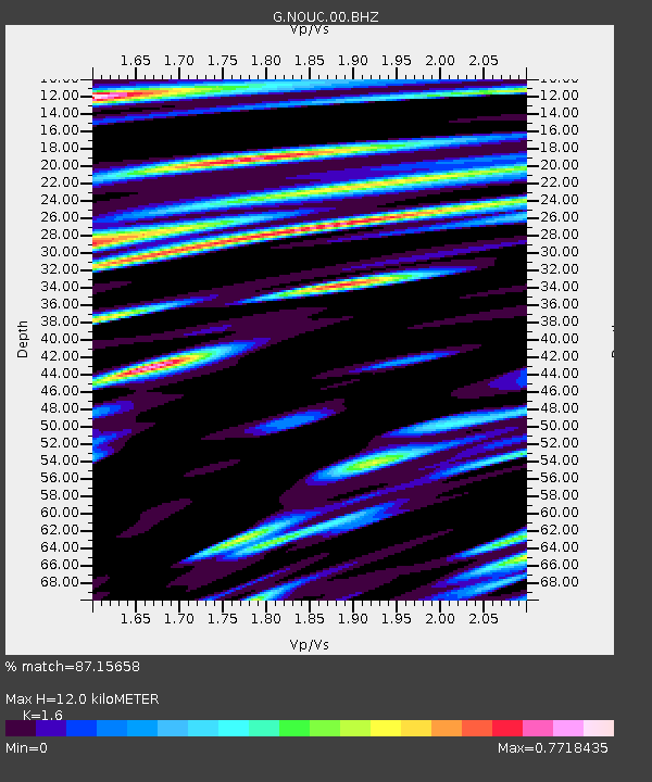
| Estimated Moho Depth: |
12.0 km |
| Estimated Crust Vp/Vs: |
1.60 |
| Assumed Crust Vp: |
5.14 km/s |
| Estimated Crust Vs: |
3.212 km/s |
| Estimated Crust Poisson's Ratio: |
0.18 |
|
| Radial Match: |
87.15658 % |
| Radial Bump: |
400 |
| Transverse Match: |
85.45863 % |
| Transverse Bump: |
400 |
| SOD ConfigId: |
1943534 |
| Insert Time: |
2017-01-24 06:20:36.228 +0000 |
| GWidth: |
2.5 |
| Max Bumps: |
400 |
| Tol: |
0.001 |
|
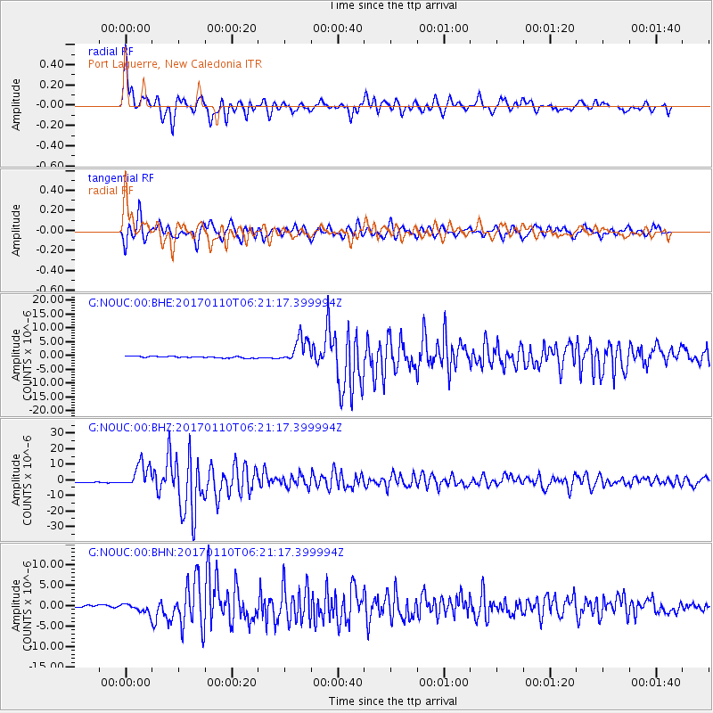
Signal To Noise
| Channel | StoN | STA | LTA |
| G:NOUC:00:BHZ:20170110T06:21:17.399994Z | 23.318905 | 7.904276E-6 | 3.3896427E-7 |
| G:NOUC:00:BHN:20170110T06:21:17.399994Z | 4.477974 | 1.2148876E-6 | 2.7130295E-7 |
| G:NOUC:00:BHE:20170110T06:21:17.399994Z | 16.759825 | 4.7483063E-6 | 2.833148E-7 |
| Arrivals |
| Ps | 1.5 SECOND |
| PpPs | 5.9 SECOND |
| PsPs/PpSs | 7.3 SECOND |


