You are here: Home > Network List > TA - USArray Transportable Network (new EarthScope stations) Stations List
> Station G10A Bishop Fram, Joseph, OR, USA > Earthquake Result Viewer
G10A Bishop Fram, Joseph, OR, USA - Earthquake Result Viewer
| Earthquake location: |
Taiwan Region |
| Earthquake latitude/longitude: |
24.3/122.2 |
| Earthquake time(UTC): |
2007/09/06 (249) 17:51:26 GMT |
| Earthquake Depth: |
53 km |
| Earthquake Magnitude: |
6.1 MB, 6.2 MW, 6.1 ME |
| Earthquake Catalog/Contributor: |
WHDF/NEIC |
|
| Network: |
TA USArray Transportable Network (new EarthScope stations) |
| Station: |
G10A Bishop Fram, Joseph, OR, USA |
| Lat/Lon: |
45.29 N/117.12 W |
| Elevation: |
1527 m |
|
| Distance: |
92.2 deg |
| Az: |
37.418 deg |
| Baz: |
308.261 deg |
| Ray Param: |
0.04147946 |
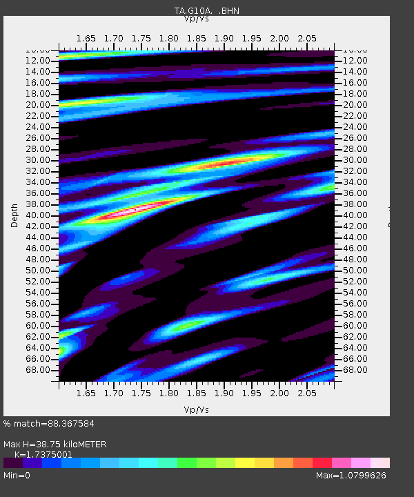
| Estimated Moho Depth: |
38.75 km |
| Estimated Crust Vp/Vs: |
1.74 |
| Assumed Crust Vp: |
6.571 km/s |
| Estimated Crust Vs: |
3.782 km/s |
| Estimated Crust Poisson's Ratio: |
0.25 |
|
| Radial Match: |
88.367584 % |
| Radial Bump: |
400 |
| Transverse Match: |
88.74 % |
| Transverse Bump: |
400 |
| SOD ConfigId: |
2564 |
| Insert Time: |
2010-03-07 03:44:18.007 +0000 |
| GWidth: |
2.5 |
| Max Bumps: |
400 |
| Tol: |
0.001 |
|

Signal To Noise
| Channel | StoN | STA | LTA |
| TA:G10A: :BHN:20070906T18:03:58.799009Z | 5.126721 | 4.6004962E-7 | 8.973565E-8 |
| TA:G10A: :BHE:20070906T18:03:58.799009Z | 2.8634064 | 2.851767E-7 | 9.9593514E-8 |
| TA:G10A: :BHZ:20070906T18:03:58.799009Z | 19.573494 | 1.6692218E-6 | 8.52797E-8 |
| Arrivals |
| Ps | 4.4 SECOND |
| PpPs | 16 SECOND |
| PsPs/PpSs | 20 SECOND |


