You are here: Home > Network List > TA - USArray Transportable Network (new EarthScope stations) Stations List
> Station G10A Bishop Fram, Joseph, OR, USA > Earthquake Result Viewer
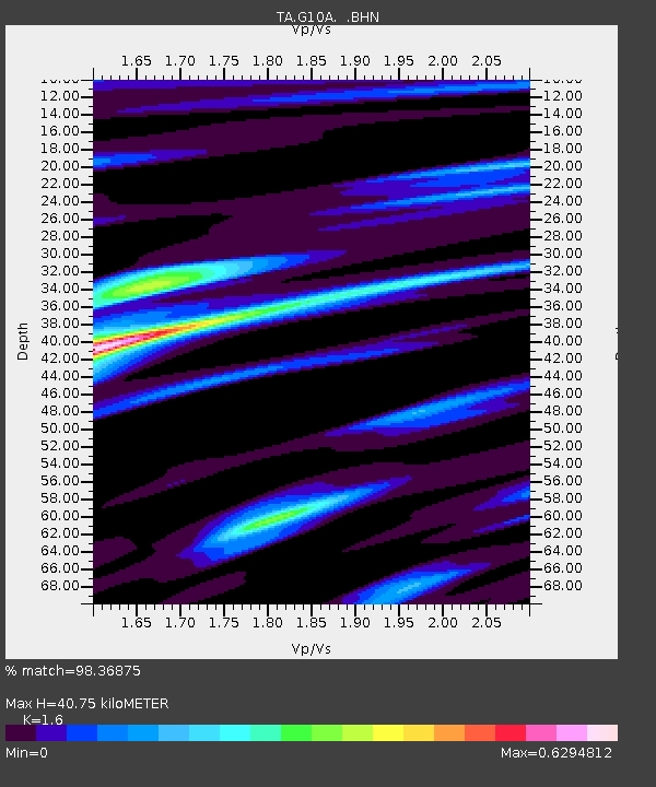
G10A Bishop Fram, Joseph, OR, USA - Earthquake Result Viewer
| Earthquake location: |
Santa Cruz Islands |
| Earthquake latitude/longitude: |
-11.6/165.8 |
| Earthquake time(UTC): |
2007/09/02 (245) 01:05:18 GMT |
| Earthquake Depth: |
35 km |
| Earthquake Magnitude: |
5.9 MB, 7.3 MS, 7.2 MW, 6.9 ME |
| Earthquake Catalog/Contributor: |
WHDF/NEIC |
|
| Network: |
TA USArray Transportable Network (new EarthScope stations) |
| Station: |
G10A Bishop Fram, Joseph, OR, USA |
| Lat/Lon: |
45.29 N/117.12 W |
| Elevation: |
1527 m |
|
| Distance: |
89.3 deg |
| Az: |
43.484 deg |
| Baz: |
252.788 deg |
| Ray Param: |
0.041920368 |
| Estimated Moho Depth: |
40.75 km |
| Estimated Crust Vp/Vs: |
1.60 |
| Assumed Crust Vp: |
6.571 km/s |
| Estimated Crust Vs: |
4.107 km/s |
| Estimated Crust Poisson's Ratio: |
0.18 |
|
| Radial Match: |
98.36875 % |
| Radial Bump: |
349 |
| Transverse Match: |
93.08476 % |
| Transverse Bump: |
400 |
| SOD ConfigId: |
2564 |
| Insert Time: |
2010-03-07 03:44:19.420 +0000 |
| GWidth: |
2.5 |
| Max Bumps: |
400 |
| Tol: |
0.001 |
|

Signal To Noise
| Channel | StoN | STA | LTA |
| TA:G10A: :BHN:20070902T01:17:39.449011Z | 4.171802 | 2.4254402E-7 | 5.8138912E-8 |
| TA:G10A: :BHE:20070902T01:17:39.449011Z | 13.005875 | 7.4333167E-7 | 5.715353E-8 |
| TA:G10A: :BHZ:20070902T01:17:39.449011Z | 32.876698 | 2.181331E-6 | 6.6348846E-8 |
| Arrivals |
| Ps | 3.8 SECOND |
| PpPs | 16 SECOND |
| PsPs/PpSs | 20 SECOND |


