You are here: Home > Network List > TA - USArray Transportable Network (new EarthScope stations) Stations List
> Station G10A Bishop Fram, Joseph, OR, USA > Earthquake Result Viewer
G10A Bishop Fram, Joseph, OR, USA - Earthquake Result Viewer
| Earthquake location: |
Tonga Islands |
| Earthquake latitude/longitude: |
-17.5/-174.3 |
| Earthquake time(UTC): |
2007/08/26 (238) 12:37:31 GMT |
| Earthquake Depth: |
127 km |
| Earthquake Magnitude: |
5.9 MB, 6.1 MW |
| Earthquake Catalog/Contributor: |
WHDF/NEIC |
|
| Network: |
TA USArray Transportable Network (new EarthScope stations) |
| Station: |
G10A Bishop Fram, Joseph, OR, USA |
| Lat/Lon: |
45.29 N/117.12 W |
| Elevation: |
1527 m |
|
| Distance: |
81.2 deg |
| Az: |
36.91 deg |
| Baz: |
234.302 deg |
| Ray Param: |
0.04748302 |
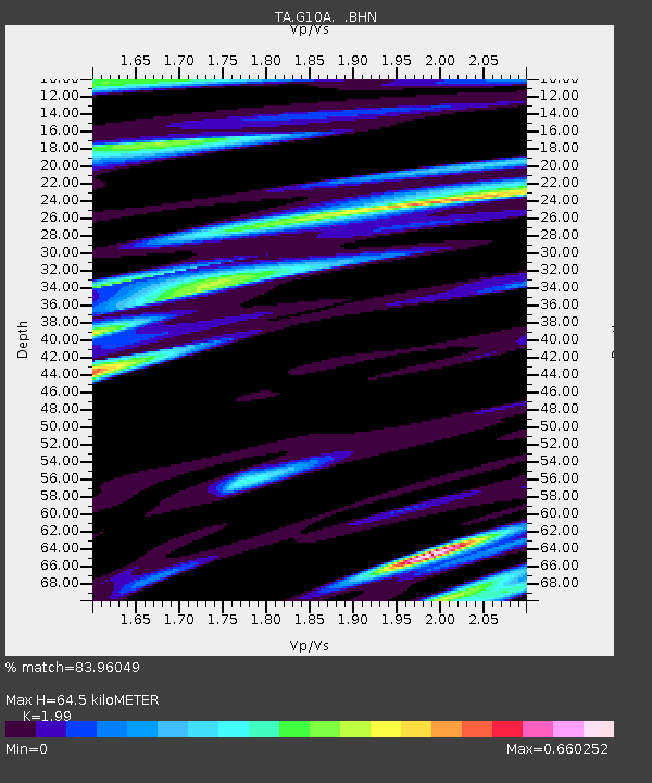
| Estimated Moho Depth: |
64.5 km |
| Estimated Crust Vp/Vs: |
1.99 |
| Assumed Crust Vp: |
6.571 km/s |
| Estimated Crust Vs: |
3.302 km/s |
| Estimated Crust Poisson's Ratio: |
0.33 |
|
| Radial Match: |
83.96049 % |
| Radial Bump: |
400 |
| Transverse Match: |
83.8276 % |
| Transverse Bump: |
400 |
| SOD ConfigId: |
2564 |
| Insert Time: |
2010-03-07 03:44:21.426 +0000 |
| GWidth: |
2.5 |
| Max Bumps: |
400 |
| Tol: |
0.001 |
|

Signal To Noise
| Channel | StoN | STA | LTA |
| TA:G10A: :BHN:20070826T12:49:01.525022Z | 3.40116 | 1.6869382E-7 | 4.9598906E-8 |
| TA:G10A: :BHE:20070826T12:49:01.525022Z | 6.3589187 | 2.0571389E-7 | 3.235045E-8 |
| TA:G10A: :BHZ:20070826T12:49:01.525022Z | 13.416905 | 7.5277234E-7 | 5.6106256E-8 |
| Arrivals |
| Ps | 10.0 SECOND |
| PpPs | 29 SECOND |
| PsPs/PpSs | 39 SECOND |


