You are here: Home > Network List > IU - Global Seismograph Network (GSN - IRIS/USGS) Stations List
> Station FURI Mt. Furi, Ethiopia > Earthquake Result Viewer
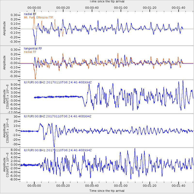
FURI Mt. Furi, Ethiopia - Earthquake Result Viewer
*The percent match for this event was below the threshold and hence no stack was calculated.
| Earthquake location: |
Celebes Sea |
| Earthquake latitude/longitude: |
4.4/122.7 |
| Earthquake time(UTC): |
2017/01/10 (010) 06:13:48 GMT |
| Earthquake Depth: |
622 km |
| Earthquake Magnitude: |
6.9 Mi |
| Earthquake Catalog/Contributor: |
NEIC PDE/at |
|
| Network: |
IU Global Seismograph Network (GSN - IRIS/USGS) |
| Station: |
FURI Mt. Furi, Ethiopia |
| Lat/Lon: |
8.90 N/38.68 E |
| Elevation: |
2570 m |
|
| Distance: |
83.4 deg |
| Az: |
278.41 deg |
| Baz: |
86.553 deg |
| Ray Param: |
$rayparam |
*The percent match for this event was below the threshold and hence was not used in the summary stack. |
|
| Radial Match: |
80.04886 % |
| Radial Bump: |
400 |
| Transverse Match: |
82.26741 % |
| Transverse Bump: |
400 |
| SOD ConfigId: |
1943534 |
| Insert Time: |
2017-01-24 06:21:23.215 +0000 |
| GWidth: |
2.5 |
| Max Bumps: |
400 |
| Tol: |
0.001 |
|
Signal To Noise
| Channel | StoN | STA | LTA |
| IU:FURI:00:BHZ:20170110T06:24:40.468994Z | 13.5934305 | 7.029303E-6 | 5.171103E-7 |
| IU:FURI:00:BH1:20170110T06:24:40.468994Z | 1.898951 | 5.077112E-7 | 2.6736402E-7 |
| IU:FURI:00:BH2:20170110T06:24:40.468994Z | 5.6551485 | 1.7337074E-6 | 3.065715E-7 |
| Arrivals |
| Ps | |
| PpPs | |
| PsPs/PpSs | |


