You are here: Home > Network List > TA - USArray Transportable Network (new EarthScope stations) Stations List
> Station G10A Bishop Fram, Joseph, OR, USA > Earthquake Result Viewer
G10A Bishop Fram, Joseph, OR, USA - Earthquake Result Viewer
| Earthquake location: |
Andreanof Islands, Aleutian Is. |
| Earthquake latitude/longitude: |
52.2/-178.7 |
| Earthquake time(UTC): |
2008/03/22 (082) 21:24:11 GMT |
| Earthquake Depth: |
132 km |
| Earthquake Magnitude: |
5.8 MB, 6.2 MW, 6.1 MW |
| Earthquake Catalog/Contributor: |
WHDF/NEIC |
|
| Network: |
TA USArray Transportable Network (new EarthScope stations) |
| Station: |
G10A Bishop Fram, Joseph, OR, USA |
| Lat/Lon: |
45.29 N/117.12 W |
| Elevation: |
1527 m |
|
| Distance: |
40.1 deg |
| Az: |
74.547 deg |
| Baz: |
302.768 deg |
| Ray Param: |
0.074130654 |
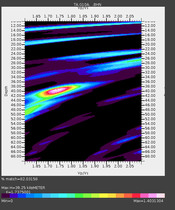
| Estimated Moho Depth: |
39.25 km |
| Estimated Crust Vp/Vs: |
1.74 |
| Assumed Crust Vp: |
6.571 km/s |
| Estimated Crust Vs: |
3.782 km/s |
| Estimated Crust Poisson's Ratio: |
0.25 |
|
| Radial Match: |
82.03158 % |
| Radial Bump: |
345 |
| Transverse Match: |
70.70298 % |
| Transverse Bump: |
400 |
| SOD ConfigId: |
2564 |
| Insert Time: |
2010-03-07 03:44:45.566 +0000 |
| GWidth: |
2.5 |
| Max Bumps: |
400 |
| Tol: |
0.001 |
|

Signal To Noise
| Channel | StoN | STA | LTA |
| TA:G10A: :BHN:20080322T21:31:03.548015Z | 2.5945413 | 7.829677E-7 | 3.01775E-7 |
| TA:G10A: :BHE:20080322T21:31:03.548015Z | 5.039037 | 1.1093704E-6 | 2.2015523E-7 |
| TA:G10A: :BHZ:20080322T21:31:03.548015Z | 8.1019945 | 2.1238304E-6 | 2.6213672E-7 |
| Arrivals |
| Ps | 4.7 SECOND |
| PpPs | 15 SECOND |
| PsPs/PpSs | 20 SECOND |


