You are here: Home > Network List > TS - TERRAscope (Southern California Seismic Network) Stations List
> Station MLAC Mammoth Lakes, California, USA > Earthquake Result Viewer
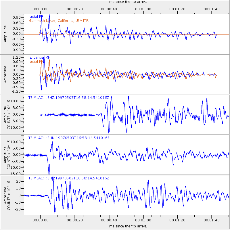
MLAC Mammoth Lakes, California, USA - Earthquake Result Viewer
*The percent match for this event was below the threshold and hence no stack was calculated.
| Earthquake location: |
Kermadec Islands Region |
| Earthquake latitude/longitude: |
-31.8/-179.4 |
| Earthquake time(UTC): |
1997/05/03 (123) 16:46:02 GMT |
| Earthquake Depth: |
108 km |
| Earthquake Magnitude: |
6.6 MB, 6.9 UNKNOWN, 6.8 ME |
| Earthquake Catalog/Contributor: |
WHDF/NEIC |
|
| Network: |
TS TERRAscope (Southern California Seismic Network) |
| Station: |
MLAC Mammoth Lakes, California, USA |
| Lat/Lon: |
37.63 N/118.83 W |
| Elevation: |
2170 m |
|
| Distance: |
89.2 deg |
| Az: |
43.741 deg |
| Baz: |
227.866 deg |
| Ray Param: |
$rayparam |
*The percent match for this event was below the threshold and hence was not used in the summary stack. |
|
| Radial Match: |
70.16198 % |
| Radial Bump: |
400 |
| Transverse Match: |
79.94363 % |
| Transverse Bump: |
400 |
| SOD ConfigId: |
4480 |
| Insert Time: |
2010-02-26 14:27:08.539 +0000 |
| GWidth: |
2.5 |
| Max Bumps: |
400 |
| Tol: |
0.001 |
|
Signal To Noise
| Channel | StoN | STA | LTA |
| TS:MLAC: :BHN:19970503T16:58:14.541016Z | 15.852817 | 3.9907286E-6 | 2.5173625E-7 |
| TS:MLAC: :BHE:19970503T16:58:14.541016Z | 2.7356453 | 9.618522E-7 | 3.5159974E-7 |
| TS:MLAC: :BHZ:19970503T16:58:14.541016Z | 0.74839747 | 2.8145658E-7 | 3.76079E-7 |
| Arrivals |
| Ps | |
| PpPs | |
| PsPs/PpSs | |


