You are here: Home > Network List > GS - US Geological Survey Networks Stations List
> Station CA04 CA04, Garlock Fault > Earthquake Result Viewer
CA04 CA04, Garlock Fault - Earthquake Result Viewer
| Earthquake location: |
Hokkaido, Japan Region |
| Earthquake latitude/longitude: |
41.1/143.0 |
| Earthquake time(UTC): |
2019/08/28 (240) 23:46:39 GMT |
| Earthquake Depth: |
17 km |
| Earthquake Magnitude: |
6.1 Mww |
| Earthquake Catalog/Contributor: |
NEIC PDE/us |
|
| Network: |
GS US Geological Survey Networks |
| Station: |
CA04 CA04, Garlock Fault |
| Lat/Lon: |
35.48 N/117.56 W |
| Elevation: |
1005 m |
|
| Distance: |
73.9 deg |
| Az: |
56.915 deg |
| Baz: |
309.092 deg |
| Ray Param: |
0.052664205 |
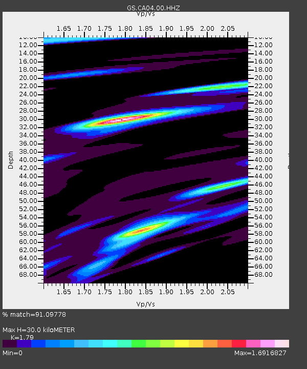
| Estimated Moho Depth: |
30.0 km |
| Estimated Crust Vp/Vs: |
1.79 |
| Assumed Crust Vp: |
6.276 km/s |
| Estimated Crust Vs: |
3.506 km/s |
| Estimated Crust Poisson's Ratio: |
0.27 |
|
| Radial Match: |
91.09778 % |
| Radial Bump: |
400 |
| Transverse Match: |
71.43162 % |
| Transverse Bump: |
400 |
| SOD ConfigId: |
19053131 |
| Insert Time: |
2019-09-11 23:54:21.547 +0000 |
| GWidth: |
2.5 |
| Max Bumps: |
400 |
| Tol: |
0.001 |
|

Signal To Noise
| Channel | StoN | STA | LTA |
| GS:CA04:00:HHZ:20190828T23:57:42.254025Z | 5.113574 | 2.662946E-7 | 5.207602E-8 |
| GS:CA04:00:HH1:20190828T23:57:42.254025Z | 1.9994993 | 1.3033298E-7 | 6.51828E-8 |
| GS:CA04:00:HH2:20190828T23:57:42.254025Z | 1.9967458 | 1.7688797E-7 | 8.858812E-8 |
| Arrivals |
| Ps | 3.9 SECOND |
| PpPs | 13 SECOND |
| PsPs/PpSs | 17 SECOND |


