You are here: Home > Network List > IW - Intermountain West Stations List
> Station TPAW Teton Pass, Wyoming, USA > Earthquake Result Viewer
TPAW Teton Pass, Wyoming, USA - Earthquake Result Viewer
| Earthquake location: |
Hokkaido, Japan Region |
| Earthquake latitude/longitude: |
41.1/143.0 |
| Earthquake time(UTC): |
2019/08/28 (240) 23:46:39 GMT |
| Earthquake Depth: |
17 km |
| Earthquake Magnitude: |
6.1 Mww |
| Earthquake Catalog/Contributor: |
NEIC PDE/us |
|
| Network: |
IW Intermountain West |
| Station: |
TPAW Teton Pass, Wyoming, USA |
| Lat/Lon: |
43.49 N/110.95 W |
| Elevation: |
2512 m |
|
| Distance: |
72.7 deg |
| Az: |
47.085 deg |
| Baz: |
310.466 deg |
| Ray Param: |
0.053446352 |
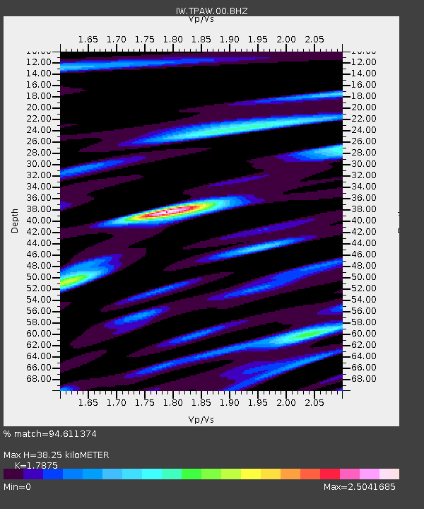
| Estimated Moho Depth: |
38.25 km |
| Estimated Crust Vp/Vs: |
1.79 |
| Assumed Crust Vp: |
6.207 km/s |
| Estimated Crust Vs: |
3.472 km/s |
| Estimated Crust Poisson's Ratio: |
0.27 |
|
| Radial Match: |
94.611374 % |
| Radial Bump: |
400 |
| Transverse Match: |
90.67064 % |
| Transverse Bump: |
400 |
| SOD ConfigId: |
19053131 |
| Insert Time: |
2019-09-11 23:55:01.888 +0000 |
| GWidth: |
2.5 |
| Max Bumps: |
400 |
| Tol: |
0.001 |
|

Signal To Noise
| Channel | StoN | STA | LTA |
| IW:TPAW:00:BHZ:20190828T23:57:35.299985Z | 6.775365 | 3.4922587E-7 | 5.1543473E-8 |
| IW:TPAW:00:BH1:20190828T23:57:35.299985Z | 2.360091 | 7.3123175E-8 | 3.09832E-8 |
| IW:TPAW:00:BH2:20190828T23:57:35.299985Z | 1.3458035 | 9.682406E-8 | 7.194517E-8 |
| Arrivals |
| Ps | 5.0 SECOND |
| PpPs | 17 SECOND |
| PsPs/PpSs | 22 SECOND |


