You are here: Home > Network List > PF - Volcanologic Network of Piton de Fournaise-OVPF Stations List
> Station HDL Station Sismologique de Hubert Delisle > Earthquake Result Viewer
HDL Station Sismologique de Hubert Delisle - Earthquake Result Viewer
| Earthquake location: |
Celebes Sea |
| Earthquake latitude/longitude: |
4.4/122.7 |
| Earthquake time(UTC): |
2017/01/10 (010) 06:13:48 GMT |
| Earthquake Depth: |
622 km |
| Earthquake Magnitude: |
6.9 Mi |
| Earthquake Catalog/Contributor: |
NEIC PDE/at |
|
| Network: |
PF Volcanologic Network of Piton de Fournaise-OVPF |
| Station: |
HDL Station Sismologique de Hubert Delisle |
| Lat/Lon: |
21.25 S/55.79 E |
| Elevation: |
242 m |
|
| Distance: |
70.3 deg |
| Az: |
245.71 deg |
| Baz: |
76.97 deg |
| Ray Param: |
0.052891113 |
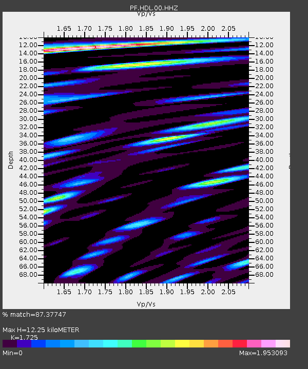
| Estimated Moho Depth: |
12.25 km |
| Estimated Crust Vp/Vs: |
1.73 |
| Assumed Crust Vp: |
4.73 km/s |
| Estimated Crust Vs: |
2.742 km/s |
| Estimated Crust Poisson's Ratio: |
0.25 |
|
| Radial Match: |
87.37747 % |
| Radial Bump: |
400 |
| Transverse Match: |
72.396774 % |
| Transverse Bump: |
400 |
| SOD ConfigId: |
1943534 |
| Insert Time: |
2017-01-24 06:22:30.909 +0000 |
| GWidth: |
2.5 |
| Max Bumps: |
400 |
| Tol: |
0.001 |
|
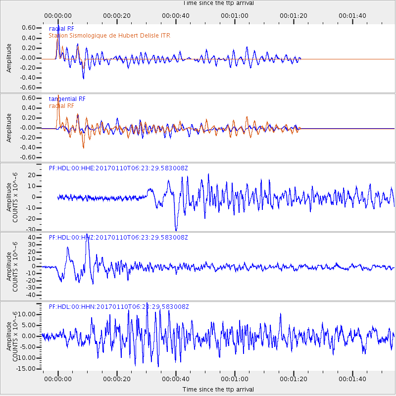
Signal To Noise
| Channel | StoN | STA | LTA |
| PF:HDL:00:HHZ:20170110T06:23:29.583008Z | 24.912083 | 1.3250957E-5 | 5.319088E-7 |
| PF:HDL:00:HHN:20170110T06:23:29.583008Z | 1.8091902 | 1.6652384E-6 | 9.204331E-7 |
| PF:HDL:00:HHE:20170110T06:23:29.583008Z | 5.0199585 | 5.499007E-6 | 1.0954287E-6 |
| Arrivals |
| Ps | 1.9 SECOND |
| PpPs | 6.9 SECOND |
| PsPs/PpSs | 8.8 SECOND |


