You are here: Home > Network List > TS - TERRAscope (Southern California Seismic Network) Stations List
> Station MLAC Mammoth Lakes, California, USA > Earthquake Result Viewer
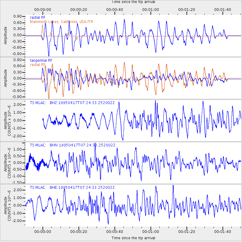
MLAC Mammoth Lakes, California, USA - Earthquake Result Viewer
*The percent match for this event was below the threshold and hence no stack was calculated.
| Earthquake location: |
Northern Mid-Atlantic Ridge |
| Earthquake latitude/longitude: |
33.8/-38.6 |
| Earthquake time(UTC): |
1995/04/17 (107) 07:14:35 GMT |
| Earthquake Depth: |
10 km |
| Earthquake Magnitude: |
5.8 MB, 5.8 MS, 5.9 UNKNOWN, 6.1 MW |
| Earthquake Catalog/Contributor: |
WHDF/NEIC |
|
| Network: |
TS TERRAscope (Southern California Seismic Network) |
| Station: |
MLAC Mammoth Lakes, California, USA |
| Lat/Lon: |
37.63 N/118.83 W |
| Elevation: |
2170 m |
|
| Distance: |
63.3 deg |
| Az: |
298.898 deg |
| Baz: |
66.703 deg |
| Ray Param: |
$rayparam |
*The percent match for this event was below the threshold and hence was not used in the summary stack. |
|
| Radial Match: |
57.923515 % |
| Radial Bump: |
400 |
| Transverse Match: |
58.89053 % |
| Transverse Bump: |
400 |
| SOD ConfigId: |
4480 |
| Insert Time: |
2010-02-26 14:27:13.676 +0000 |
| GWidth: |
2.5 |
| Max Bumps: |
400 |
| Tol: |
0.001 |
|
Signal To Noise
| Channel | StoN | STA | LTA |
| TS:MLAC: :BHN:19950417T07:24:33.252002Z | 0.81485873 | 2.8470174E-7 | 3.4938788E-7 |
| TS:MLAC: :BHE:19950417T07:24:33.252002Z | 0.96475196 | 7.145948E-7 | 7.407032E-7 |
| TS:MLAC: :BHZ:19950417T07:24:33.252002Z | 1.2650472 | 6.372243E-7 | 5.037158E-7 |
| Arrivals |
| Ps | |
| PpPs | |
| PsPs/PpSs | |


