You are here: Home > Network List > RV - Regional Alberta Seismic Observatory for Earthquake Studies Network Stations List
> Station KIMIA Kimiwan Lookout Tower, AB > Earthquake Result Viewer
KIMIA Kimiwan Lookout Tower, AB - Earthquake Result Viewer
| Earthquake location: |
Hokkaido, Japan Region |
| Earthquake latitude/longitude: |
41.1/143.0 |
| Earthquake time(UTC): |
2019/08/28 (240) 23:46:39 GMT |
| Earthquake Depth: |
17 km |
| Earthquake Magnitude: |
6.1 Mww |
| Earthquake Catalog/Contributor: |
NEIC PDE/us |
|
| Network: |
RV Regional Alberta Seismic Observatory for Earthquake Studies Network |
| Station: |
KIMIA Kimiwan Lookout Tower, AB |
| Lat/Lon: |
55.99 N/116.61 W |
| Elevation: |
764 m |
|
| Distance: |
62.3 deg |
| Az: |
38.618 deg |
| Baz: |
302.878 deg |
| Ray Param: |
0.06029736 |
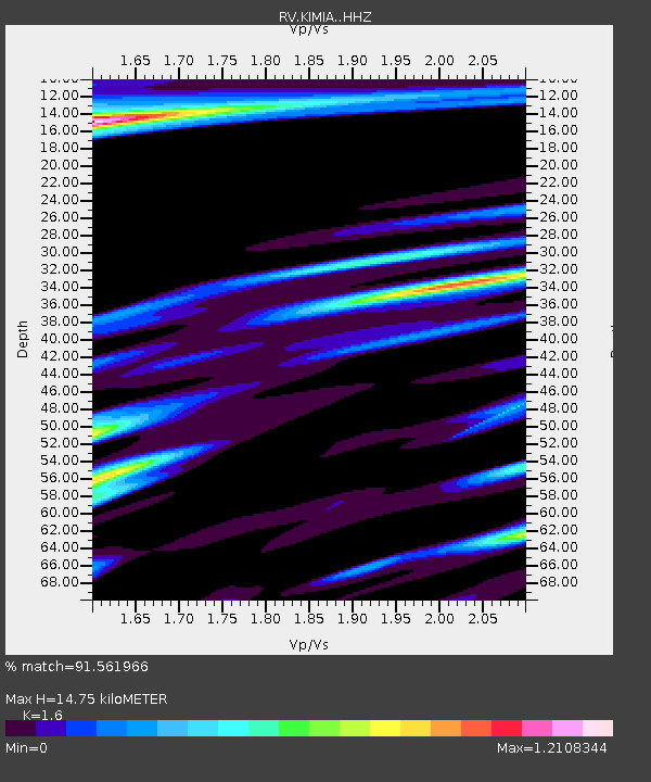
| Estimated Moho Depth: |
14.75 km |
| Estimated Crust Vp/Vs: |
1.60 |
| Assumed Crust Vp: |
6.426 km/s |
| Estimated Crust Vs: |
4.016 km/s |
| Estimated Crust Poisson's Ratio: |
0.18 |
|
| Radial Match: |
91.561966 % |
| Radial Bump: |
398 |
| Transverse Match: |
69.71301 % |
| Transverse Bump: |
380 |
| SOD ConfigId: |
19053131 |
| Insert Time: |
2019-09-11 23:59:06.020 +0000 |
| GWidth: |
2.5 |
| Max Bumps: |
400 |
| Tol: |
0.001 |
|

Signal To Noise
| Channel | StoN | STA | LTA |
| RV:KIMIA: :HHZ:20190828T23:56:29.510007Z | 8.095687 | 7.7673866E-7 | 9.594475E-8 |
| RV:KIMIA: :HHN:20190828T23:56:29.510007Z | 1.1558495 | 3.2468157E-7 | 2.80903E-7 |
| RV:KIMIA: :HHE:20190828T23:56:29.510007Z | 1.1104125 | 3.0856907E-7 | 2.7788687E-7 |
| Arrivals |
| Ps | 1.4 SECOND |
| PpPs | 5.7 SECOND |
| PsPs/PpSs | 7.1 SECOND |


