You are here: Home > Network List > TA - USArray Transportable Network (new EarthScope stations) Stations List
> Station B22K Teshekpuk Lake, AK, USA > Earthquake Result Viewer
B22K Teshekpuk Lake, AK, USA - Earthquake Result Viewer

| Earthquake location: |
Hokkaido, Japan Region |
| Earthquake latitude/longitude: |
41.1/143.0 |
| Earthquake time(UTC): |
2019/08/28 (240) 23:46:39 GMT |
| Earthquake Depth: |
17 km |
| Earthquake Magnitude: |
6.1 Mww |
| Earthquake Catalog/Contributor: |
NEIC PDE/us |
|
| Network: |
TA USArray Transportable Network (new EarthScope stations) |
| Station: |
B22K Teshekpuk Lake, AK, USA |
| Lat/Lon: |
70.34 N/153.42 W |
| Elevation: |
50 m |
|
| Distance: |
43.1 deg |
| Az: |
26.316 deg |
| Baz: |
262.02 deg |
| Ray Param: |
0.07272609 |
| Estimated Moho Depth: |
11.5 km |
| Estimated Crust Vp/Vs: |
1.69 |
| Assumed Crust Vp: |
5.738 km/s |
| Estimated Crust Vs: |
3.4 km/s |
| Estimated Crust Poisson's Ratio: |
0.23 |
|
| Radial Match: |
88.2893 % |
| Radial Bump: |
400 |
| Transverse Match: |
77.99548 % |
| Transverse Bump: |
400 |
| SOD ConfigId: |
19053131 |
| Insert Time: |
2019-09-11 23:59:35.800 +0000 |
| GWidth: |
2.5 |
| Max Bumps: |
400 |
| Tol: |
0.001 |
|
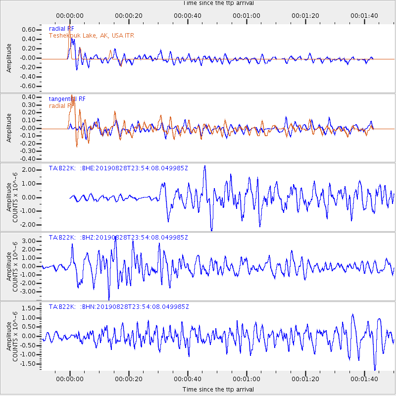
Signal To Noise
| Channel | StoN | STA | LTA |
| TA:B22K: :BHZ:20190828T23:54:08.049985Z | 12.6977625 | 1.3518461E-6 | 1.06463325E-7 |
| TA:B22K: :BHN:20190828T23:54:08.049985Z | 0.8272688 | 1.4304943E-7 | 1.7291771E-7 |
| TA:B22K: :BHE:20190828T23:54:08.049985Z | 5.8267 | 8.113476E-7 | 1.392465E-7 |
| Arrivals |
| Ps | 1.5 SECOND |
| PpPs | 5.1 SECOND |
| PsPs/PpSs | 6.6 SECOND |


