You are here: Home > Network List > TA - USArray Transportable Network (new EarthScope stations) Stations List
> Station C27K Jago River, AK, USA > Earthquake Result Viewer
C27K Jago River, AK, USA - Earthquake Result Viewer
| Earthquake location: |
Hokkaido, Japan Region |
| Earthquake latitude/longitude: |
41.1/143.0 |
| Earthquake time(UTC): |
2019/08/28 (240) 23:46:39 GMT |
| Earthquake Depth: |
17 km |
| Earthquake Magnitude: |
6.1 Mww |
| Earthquake Catalog/Contributor: |
NEIC PDE/us |
|
| Network: |
TA USArray Transportable Network (new EarthScope stations) |
| Station: |
C27K Jago River, AK, USA |
| Lat/Lon: |
69.63 N/143.71 W |
| Elevation: |
392 m |
|
| Distance: |
46.4 deg |
| Az: |
27.576 deg |
| Baz: |
272.032 deg |
| Ray Param: |
0.070627645 |
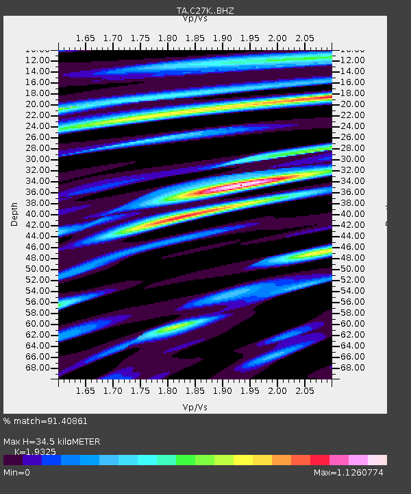
| Estimated Moho Depth: |
34.5 km |
| Estimated Crust Vp/Vs: |
1.93 |
| Assumed Crust Vp: |
6.522 km/s |
| Estimated Crust Vs: |
3.375 km/s |
| Estimated Crust Poisson's Ratio: |
0.32 |
|
| Radial Match: |
91.40861 % |
| Radial Bump: |
400 |
| Transverse Match: |
89.82608 % |
| Transverse Bump: |
400 |
| SOD ConfigId: |
19053131 |
| Insert Time: |
2019-09-11 23:59:40.025 +0000 |
| GWidth: |
2.5 |
| Max Bumps: |
400 |
| Tol: |
0.001 |
|

Signal To Noise
| Channel | StoN | STA | LTA |
| TA:C27K: :BHZ:20190828T23:54:34.299985Z | 15.905534 | 1.146192E-6 | 7.206246E-8 |
| TA:C27K: :BHN:20190828T23:54:34.299985Z | 3.9938698 | 2.3835646E-7 | 5.968058E-8 |
| TA:C27K: :BHE:20190828T23:54:34.299985Z | 6.8626723 | 5.0648424E-7 | 7.3802774E-8 |
| Arrivals |
| Ps | 5.2 SECOND |
| PpPs | 15 SECOND |
| PsPs/PpSs | 20 SECOND |


