You are here: Home > Network List > TA - USArray Transportable Network (new EarthScope stations) Stations List
> Station D22K Ayikyak River, AK, USA > Earthquake Result Viewer
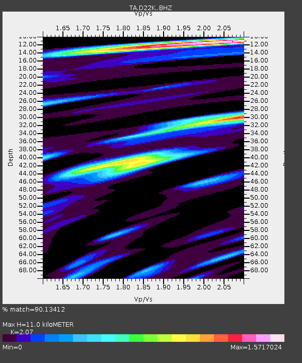
D22K Ayikyak River, AK, USA - Earthquake Result Viewer
| Earthquake location: |
Hokkaido, Japan Region |
| Earthquake latitude/longitude: |
41.1/143.0 |
| Earthquake time(UTC): |
2019/08/28 (240) 23:46:39 GMT |
| Earthquake Depth: |
17 km |
| Earthquake Magnitude: |
6.1 Mww |
| Earthquake Catalog/Contributor: |
NEIC PDE/us |
|
| Network: |
TA USArray Transportable Network (new EarthScope stations) |
| Station: |
D22K Ayikyak River, AK, USA |
| Lat/Lon: |
68.88 N/152.68 W |
| Elevation: |
532 m |
|
| Distance: |
43.2 deg |
| Az: |
28.49 deg |
| Baz: |
264.297 deg |
| Ray Param: |
0.07267352 |
| Estimated Moho Depth: |
11.0 km |
| Estimated Crust Vp/Vs: |
2.07 |
| Assumed Crust Vp: |
6.221 km/s |
| Estimated Crust Vs: |
3.005 km/s |
| Estimated Crust Poisson's Ratio: |
0.35 |
|
| Radial Match: |
90.13412 % |
| Radial Bump: |
400 |
| Transverse Match: |
81.30449 % |
| Transverse Bump: |
400 |
| SOD ConfigId: |
19053131 |
| Insert Time: |
2019-09-11 23:59:42.690 +0000 |
| GWidth: |
2.5 |
| Max Bumps: |
400 |
| Tol: |
0.001 |
|

Signal To Noise
| Channel | StoN | STA | LTA |
| TA:D22K: :BHZ:20190828T23:54:08.700009Z | 19.970976 | 1.183287E-6 | 5.925034E-8 |
| TA:D22K: :BHN:20190828T23:54:08.700009Z | 2.626972 | 1.8288385E-7 | 6.9617734E-8 |
| TA:D22K: :BHE:20190828T23:54:08.700009Z | 7.8873625 | 4.9752686E-7 | 6.307899E-8 |
| Arrivals |
| Ps | 2.0 SECOND |
| PpPs | 5.1 SECOND |
| PsPs/PpSs | 7.1 SECOND |


