You are here: Home > Network List > TA - USArray Transportable Network (new EarthScope stations) Stations List
> Station D25K Kavik River, AK, USA > Earthquake Result Viewer
D25K Kavik River, AK, USA - Earthquake Result Viewer
| Earthquake location: |
Hokkaido, Japan Region |
| Earthquake latitude/longitude: |
41.1/143.0 |
| Earthquake time(UTC): |
2019/08/28 (240) 23:46:39 GMT |
| Earthquake Depth: |
17 km |
| Earthquake Magnitude: |
6.1 Mww |
| Earthquake Catalog/Contributor: |
NEIC PDE/us |
|
| Network: |
TA USArray Transportable Network (new EarthScope stations) |
| Station: |
D25K Kavik River, AK, USA |
| Lat/Lon: |
69.32 N/146.38 W |
| Elevation: |
770 m |
|
| Distance: |
45.5 deg |
| Az: |
28.022 deg |
| Baz: |
269.849 deg |
| Ray Param: |
0.071216896 |
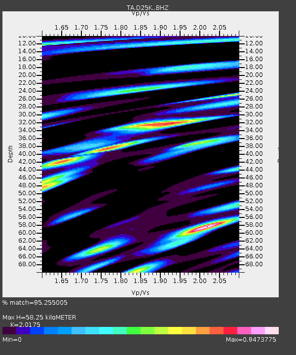
| Estimated Moho Depth: |
58.25 km |
| Estimated Crust Vp/Vs: |
2.02 |
| Assumed Crust Vp: |
6.378 km/s |
| Estimated Crust Vs: |
3.162 km/s |
| Estimated Crust Poisson's Ratio: |
0.34 |
|
| Radial Match: |
95.255005 % |
| Radial Bump: |
400 |
| Transverse Match: |
87.31899 % |
| Transverse Bump: |
400 |
| SOD ConfigId: |
19053131 |
| Insert Time: |
2019-09-11 23:59:45.043 +0000 |
| GWidth: |
2.5 |
| Max Bumps: |
400 |
| Tol: |
0.001 |
|
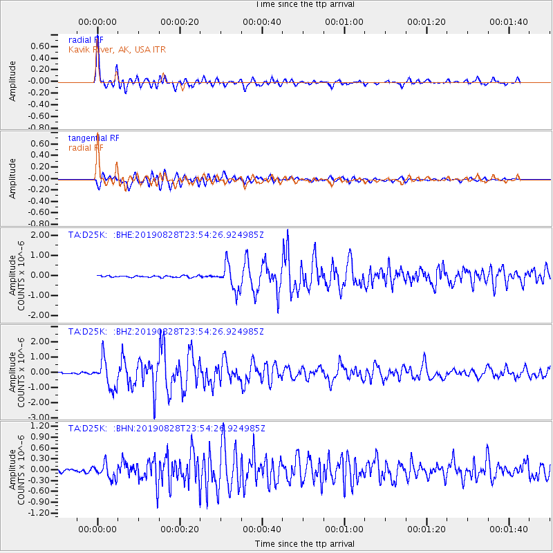
Signal To Noise
| Channel | StoN | STA | LTA |
| TA:D25K: :BHZ:20190828T23:54:26.924985Z | 24.13565 | 9.640302E-7 | 3.9942165E-8 |
| TA:D25K: :BHN:20190828T23:54:26.924985Z | 4.9044323 | 2.0925319E-7 | 4.2666137E-8 |
| TA:D25K: :BHE:20190828T23:54:26.924985Z | 15.980162 | 6.520826E-7 | 4.080576E-8 |
| Arrivals |
| Ps | 9.8 SECOND |
| PpPs | 26 SECOND |
| PsPs/PpSs | 36 SECOND |


