You are here: Home > Network List > TA - USArray Transportable Network (new EarthScope stations) Stations List
> Station E21K Killik River, AK, USA > Earthquake Result Viewer
E21K Killik River, AK, USA - Earthquake Result Viewer
| Earthquake location: |
Hokkaido, Japan Region |
| Earthquake latitude/longitude: |
41.1/143.0 |
| Earthquake time(UTC): |
2019/08/28 (240) 23:46:39 GMT |
| Earthquake Depth: |
17 km |
| Earthquake Magnitude: |
6.1 Mww |
| Earthquake Catalog/Contributor: |
NEIC PDE/us |
|
| Network: |
TA USArray Transportable Network (new EarthScope stations) |
| Station: |
E21K Killik River, AK, USA |
| Lat/Lon: |
68.44 N/153.97 W |
| Elevation: |
653 m |
|
| Distance: |
42.7 deg |
| Az: |
29.06 deg |
| Baz: |
263.513 deg |
| Ray Param: |
0.07299935 |
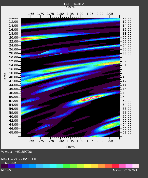
| Estimated Moho Depth: |
50.5 km |
| Estimated Crust Vp/Vs: |
1.95 |
| Assumed Crust Vp: |
6.221 km/s |
| Estimated Crust Vs: |
3.19 km/s |
| Estimated Crust Poisson's Ratio: |
0.32 |
|
| Radial Match: |
91.59736 % |
| Radial Bump: |
400 |
| Transverse Match: |
80.38595 % |
| Transverse Bump: |
400 |
| SOD ConfigId: |
19053131 |
| Insert Time: |
2019-09-11 23:59:48.577 +0000 |
| GWidth: |
2.5 |
| Max Bumps: |
400 |
| Tol: |
0.001 |
|

Signal To Noise
| Channel | StoN | STA | LTA |
| TA:E21K: :BHZ:20190828T23:54:04.524991Z | 19.288214 | 9.640742E-7 | 4.9982553E-8 |
| TA:E21K: :BHN:20190828T23:54:04.524991Z | 2.4671605 | 1.387532E-7 | 5.6240037E-8 |
| TA:E21K: :BHE:20190828T23:54:04.524991Z | 8.280196 | 4.915723E-7 | 5.9367228E-8 |
| Arrivals |
| Ps | 8.2 SECOND |
| PpPs | 23 SECOND |
| PsPs/PpSs | 31 SECOND |


