You are here: Home > Network List > TA - USArray Transportable Network (new EarthScope stations) Stations List
> Station E23K Chandalar, AK, USA > Earthquake Result Viewer
E23K Chandalar, AK, USA - Earthquake Result Viewer
| Earthquake location: |
Hokkaido, Japan Region |
| Earthquake latitude/longitude: |
41.1/143.0 |
| Earthquake time(UTC): |
2019/08/28 (240) 23:46:39 GMT |
| Earthquake Depth: |
17 km |
| Earthquake Magnitude: |
6.1 Mww |
| Earthquake Catalog/Contributor: |
NEIC PDE/us |
|
| Network: |
TA USArray Transportable Network (new EarthScope stations) |
| Station: |
E23K Chandalar, AK, USA |
| Lat/Lon: |
68.06 N/149.62 W |
| Elevation: |
1084 m |
|
| Distance: |
44.3 deg |
| Az: |
29.79 deg |
| Baz: |
268.084 deg |
| Ray Param: |
0.07198691 |
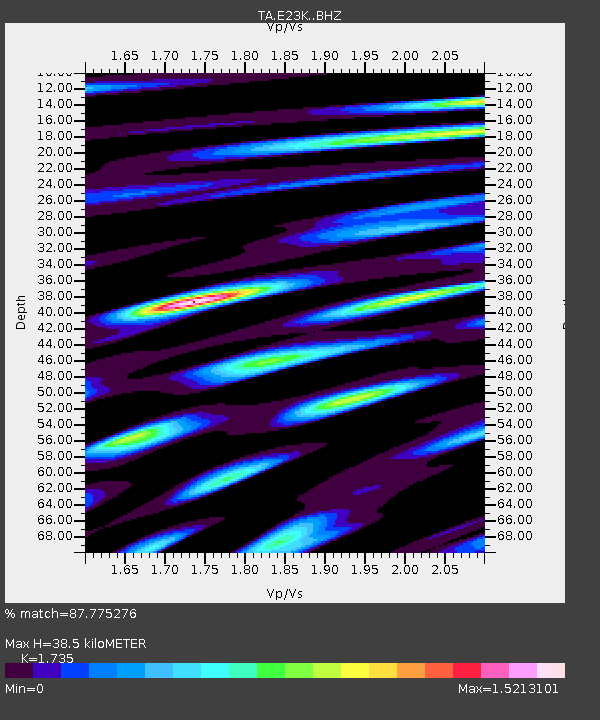
| Estimated Moho Depth: |
38.5 km |
| Estimated Crust Vp/Vs: |
1.74 |
| Assumed Crust Vp: |
6.316 km/s |
| Estimated Crust Vs: |
3.64 km/s |
| Estimated Crust Poisson's Ratio: |
0.25 |
|
| Radial Match: |
87.775276 % |
| Radial Bump: |
400 |
| Transverse Match: |
82.50112 % |
| Transverse Bump: |
400 |
| SOD ConfigId: |
19053131 |
| Insert Time: |
2019-09-11 23:59:49.784 +0000 |
| GWidth: |
2.5 |
| Max Bumps: |
400 |
| Tol: |
0.001 |
|

Signal To Noise
| Channel | StoN | STA | LTA |
| TA:E23K: :BHZ:20190828T23:54:17.325009Z | 16.73664 | 1.0434419E-6 | 6.234476E-8 |
| TA:E23K: :BHN:20190828T23:54:17.325009Z | 4.778676 | 1.6480503E-7 | 3.448759E-8 |
| TA:E23K: :BHE:20190828T23:54:17.325009Z | 13.303636 | 5.5390603E-7 | 4.1635687E-8 |
| Arrivals |
| Ps | 4.8 SECOND |
| PpPs | 16 SECOND |
| PsPs/PpSs | 20 SECOND |


