You are here: Home > Network List > TA - USArray Transportable Network (new EarthScope stations) Stations List
> Station F21K Alatna River, AK, USA > Earthquake Result Viewer
F21K Alatna River, AK, USA - Earthquake Result Viewer

| Earthquake location: |
Hokkaido, Japan Region |
| Earthquake latitude/longitude: |
41.1/143.0 |
| Earthquake time(UTC): |
2019/08/28 (240) 23:46:39 GMT |
| Earthquake Depth: |
17 km |
| Earthquake Magnitude: |
6.1 Mww |
| Earthquake Catalog/Contributor: |
NEIC PDE/us |
|
| Network: |
TA USArray Transportable Network (new EarthScope stations) |
| Station: |
F21K Alatna River, AK, USA |
| Lat/Lon: |
67.22 N/153.48 W |
| Elevation: |
597 m |
|
| Distance: |
42.8 deg |
| Az: |
30.883 deg |
| Baz: |
265.305 deg |
| Ray Param: |
0.07295841 |
| Estimated Moho Depth: |
54.25 km |
| Estimated Crust Vp/Vs: |
1.93 |
| Assumed Crust Vp: |
6.455 km/s |
| Estimated Crust Vs: |
3.345 km/s |
| Estimated Crust Poisson's Ratio: |
0.32 |
|
| Radial Match: |
85.79073 % |
| Radial Bump: |
400 |
| Transverse Match: |
69.69856 % |
| Transverse Bump: |
400 |
| SOD ConfigId: |
19053131 |
| Insert Time: |
2019-09-11 23:59:56.910 +0000 |
| GWidth: |
2.5 |
| Max Bumps: |
400 |
| Tol: |
0.001 |
|
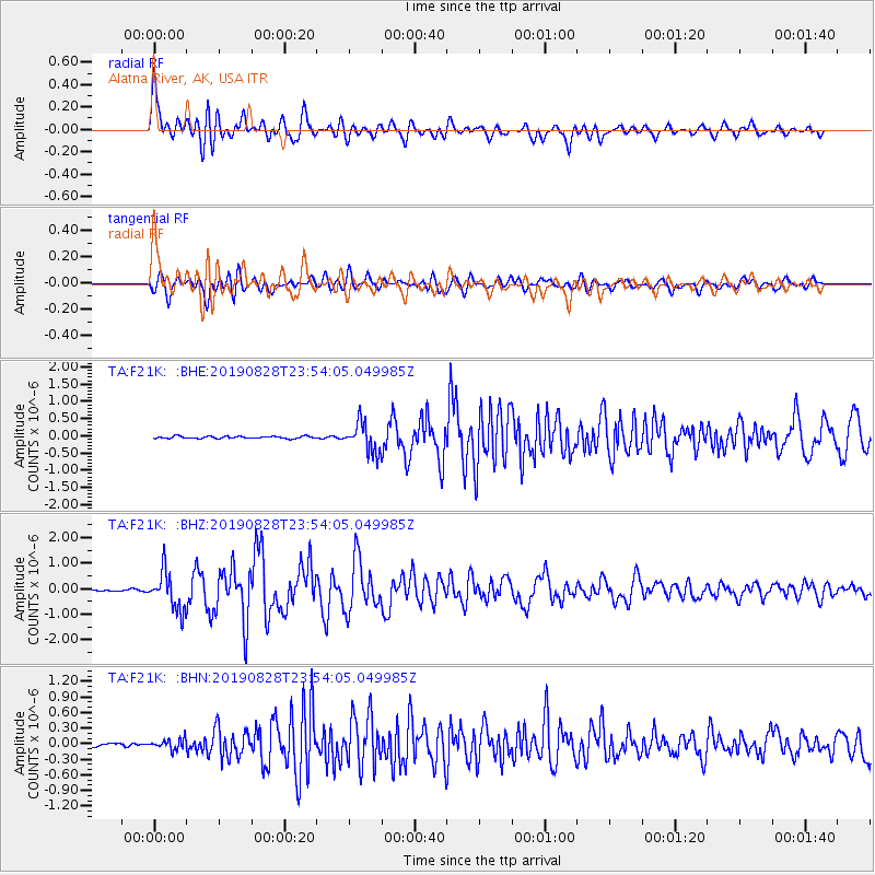
Signal To Noise
| Channel | StoN | STA | LTA |
| TA:F21K: :BHZ:20190828T23:54:05.049985Z | 18.979689 | 7.4263266E-7 | 3.912776E-8 |
| TA:F21K: :BHN:20190828T23:54:05.049985Z | 3.1388884 | 9.7035766E-8 | 3.0914055E-8 |
| TA:F21K: :BHE:20190828T23:54:05.049985Z | 13.213259 | 4.282474E-7 | 3.241043E-8 |
| Arrivals |
| Ps | 8.3 SECOND |
| PpPs | 23 SECOND |
| PsPs/PpSs | 31 SECOND |


