You are here: Home > Network List > TA - USArray Transportable Network (new EarthScope stations) Stations List
> Station G16K Koyuk River, AK, USA > Earthquake Result Viewer
G16K Koyuk River, AK, USA - Earthquake Result Viewer
| Earthquake location: |
Hokkaido, Japan Region |
| Earthquake latitude/longitude: |
41.1/143.0 |
| Earthquake time(UTC): |
2019/08/28 (240) 23:46:39 GMT |
| Earthquake Depth: |
17 km |
| Earthquake Magnitude: |
6.1 Mww |
| Earthquake Catalog/Contributor: |
NEIC PDE/us |
|
| Network: |
TA USArray Transportable Network (new EarthScope stations) |
| Station: |
G16K Koyuk River, AK, USA |
| Lat/Lon: |
65.39 N/162.35 W |
| Elevation: |
169 m |
|
| Distance: |
39.0 deg |
| Az: |
32.893 deg |
| Baz: |
258.707 deg |
| Ray Param: |
0.07523865 |
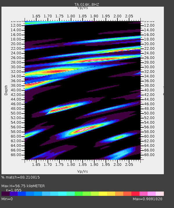
| Estimated Moho Depth: |
56.75 km |
| Estimated Crust Vp/Vs: |
1.86 |
| Assumed Crust Vp: |
6.276 km/s |
| Estimated Crust Vs: |
3.383 km/s |
| Estimated Crust Poisson's Ratio: |
0.30 |
|
| Radial Match: |
88.210815 % |
| Radial Bump: |
400 |
| Transverse Match: |
84.14221 % |
| Transverse Bump: |
400 |
| SOD ConfigId: |
19053131 |
| Insert Time: |
2019-09-12 00:00:02.483 +0000 |
| GWidth: |
2.5 |
| Max Bumps: |
400 |
| Tol: |
0.001 |
|

Signal To Noise
| Channel | StoN | STA | LTA |
| TA:G16K: :BHZ:20190828T23:53:33.774991Z | 9.145916 | 6.7175654E-7 | 7.3448795E-8 |
| TA:G16K: :BHN:20190828T23:53:33.774991Z | 2.3860269 | 1.2230471E-7 | 5.125873E-8 |
| TA:G16K: :BHE:20190828T23:53:33.774991Z | 7.6022744 | 4.2625493E-7 | 5.6069396E-8 |
| Arrivals |
| Ps | 8.3 SECOND |
| PpPs | 24 SECOND |
| PsPs/PpSs | 32 SECOND |


