You are here: Home > Network List > TA - USArray Transportable Network (new EarthScope stations) Stations List
> Station I21K Tanana, AK, USA > Earthquake Result Viewer
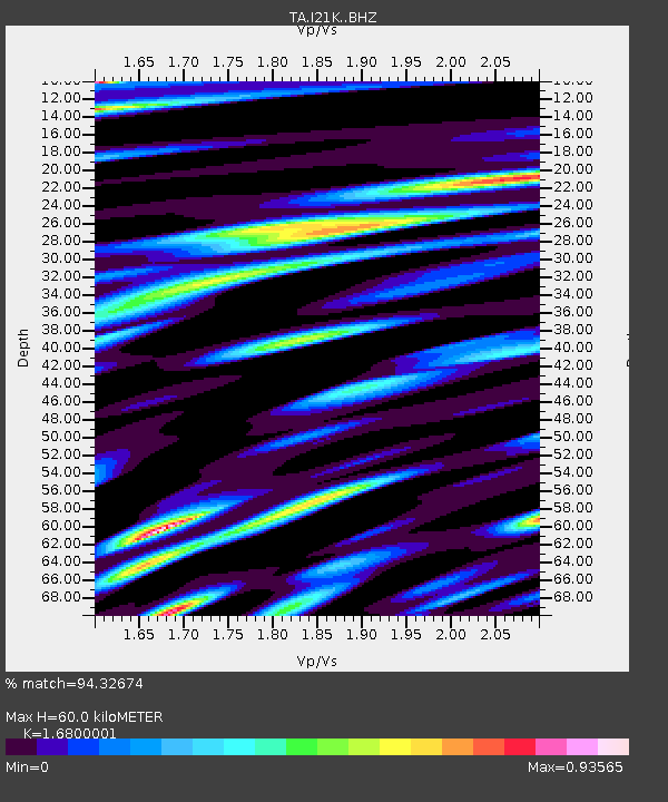
I21K Tanana, AK, USA - Earthquake Result Viewer
| Earthquake location: |
Hokkaido, Japan Region |
| Earthquake latitude/longitude: |
41.1/143.0 |
| Earthquake time(UTC): |
2019/08/28 (240) 23:46:39 GMT |
| Earthquake Depth: |
17 km |
| Earthquake Magnitude: |
6.1 Mww |
| Earthquake Catalog/Contributor: |
NEIC PDE/us |
|
| Network: |
TA USArray Transportable Network (new EarthScope stations) |
| Station: |
I21K Tanana, AK, USA |
| Lat/Lon: |
65.18 N/151.98 W |
| Elevation: |
248 m |
|
| Distance: |
43.3 deg |
| Az: |
33.931 deg |
| Baz: |
268.905 deg |
| Ray Param: |
0.07263889 |
| Estimated Moho Depth: |
60.0 km |
| Estimated Crust Vp/Vs: |
1.68 |
| Assumed Crust Vp: |
6.566 km/s |
| Estimated Crust Vs: |
3.908 km/s |
| Estimated Crust Poisson's Ratio: |
0.23 |
|
| Radial Match: |
94.32674 % |
| Radial Bump: |
400 |
| Transverse Match: |
89.32987 % |
| Transverse Bump: |
400 |
| SOD ConfigId: |
19053131 |
| Insert Time: |
2019-09-12 00:00:21.798 +0000 |
| GWidth: |
2.5 |
| Max Bumps: |
400 |
| Tol: |
0.001 |
|

Signal To Noise
| Channel | StoN | STA | LTA |
| TA:I21K: :BHZ:20190828T23:54:09.149991Z | 12.88755 | 7.9881175E-7 | 6.1983215E-8 |
| TA:I21K: :BHN:20190828T23:54:09.149991Z | 1.9694178 | 1.226386E-7 | 6.2271496E-8 |
| TA:I21K: :BHE:20190828T23:54:09.149991Z | 10.098546 | 4.875093E-7 | 4.8275194E-8 |
| Arrivals |
| Ps | 6.7 SECOND |
| PpPs | 23 SECOND |
| PsPs/PpSs | 29 SECOND |


