You are here: Home > Network List > TA - USArray Transportable Network (new EarthScope stations) Stations List
> Station I29M Ogilvie Camp, Yukon, CA > Earthquake Result Viewer
I29M Ogilvie Camp, Yukon, CA - Earthquake Result Viewer
| Earthquake location: |
Hokkaido, Japan Region |
| Earthquake latitude/longitude: |
41.1/143.0 |
| Earthquake time(UTC): |
2019/08/28 (240) 23:46:39 GMT |
| Earthquake Depth: |
17 km |
| Earthquake Magnitude: |
6.1 Mww |
| Earthquake Catalog/Contributor: |
NEIC PDE/us |
|
| Network: |
TA USArray Transportable Network (new EarthScope stations) |
| Station: |
I29M Ogilvie Camp, Yukon, CA |
| Lat/Lon: |
65.36 N/138.31 W |
| Elevation: |
602 m |
|
| Distance: |
49.0 deg |
| Az: |
33.016 deg |
| Baz: |
280.687 deg |
| Ray Param: |
0.06898077 |
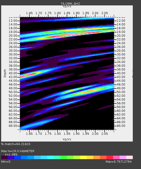
| Estimated Moho Depth: |
19.0 km |
| Estimated Crust Vp/Vs: |
1.89 |
| Assumed Crust Vp: |
6.566 km/s |
| Estimated Crust Vs: |
3.465 km/s |
| Estimated Crust Poisson's Ratio: |
0.31 |
|
| Radial Match: |
84.21633 % |
| Radial Bump: |
400 |
| Transverse Match: |
52.8474 % |
| Transverse Bump: |
400 |
| SOD ConfigId: |
19053131 |
| Insert Time: |
2019-09-12 00:00:23.311 +0000 |
| GWidth: |
2.5 |
| Max Bumps: |
400 |
| Tol: |
0.001 |
|

Signal To Noise
| Channel | StoN | STA | LTA |
| TA:I29M: :BHZ:20190828T23:54:53.999997Z | 10.679028 | 6.4137487E-7 | 6.00593E-8 |
| TA:I29M: :BHN:20190828T23:54:53.999997Z | 0.518023 | 1.6598501E-7 | 3.2042016E-7 |
| TA:I29M: :BHE:20190828T23:54:53.999997Z | 1.6899356 | 3.480214E-7 | 2.0593768E-7 |
| Arrivals |
| Ps | 2.7 SECOND |
| PpPs | 7.9 SECOND |
| PsPs/PpSs | 11 SECOND |


