You are here: Home > Network List > TA - USArray Transportable Network (new EarthScope stations) Stations List
> Station J26L Joseph Creek, AK, USA > Earthquake Result Viewer
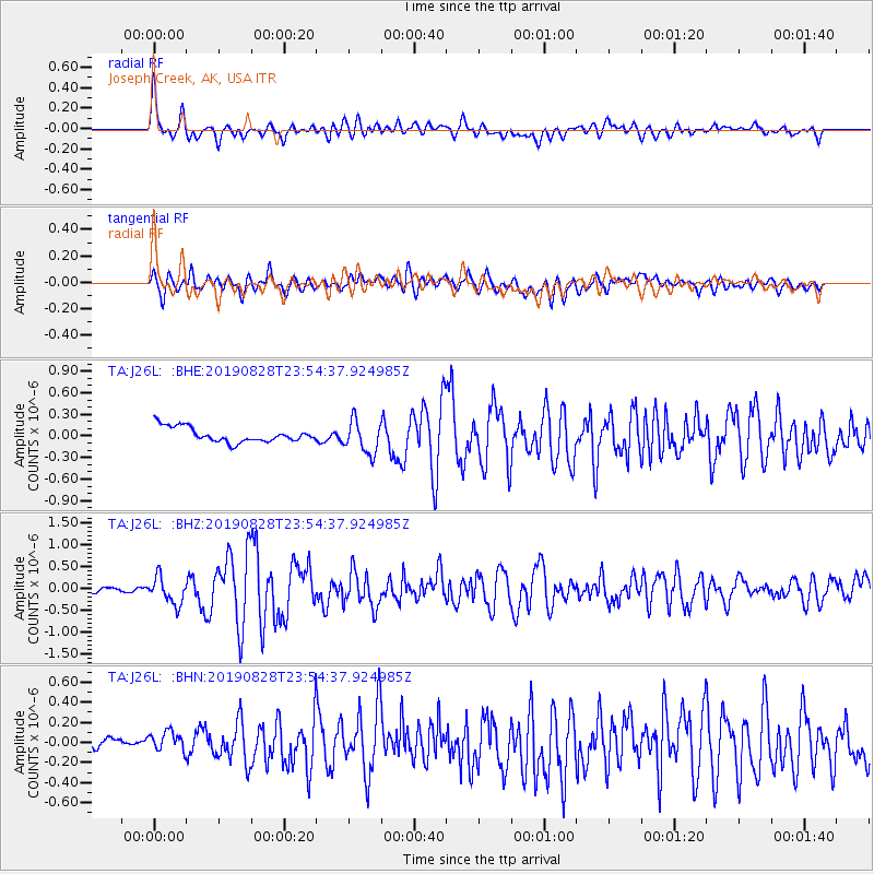
J26L Joseph Creek, AK, USA - Earthquake Result Viewer
*The percent match for this event was below the threshold and hence no stack was calculated.
| Earthquake location: |
Hokkaido, Japan Region |
| Earthquake latitude/longitude: |
41.1/143.0 |
| Earthquake time(UTC): |
2019/08/28 (240) 23:46:39 GMT |
| Earthquake Depth: |
17 km |
| Earthquake Magnitude: |
6.1 Mww |
| Earthquake Catalog/Contributor: |
NEIC PDE/us |
|
| Network: |
TA USArray Transportable Network (new EarthScope stations) |
| Station: |
J26L Joseph Creek, AK, USA |
| Lat/Lon: |
64.50 N/143.56 W |
| Elevation: |
1144 m |
|
| Distance: |
46.9 deg |
| Az: |
34.628 deg |
| Baz: |
277.01 deg |
| Ray Param: |
$rayparam |
*The percent match for this event was below the threshold and hence was not used in the summary stack. |
|
| Radial Match: |
72.800606 % |
| Radial Bump: |
400 |
| Transverse Match: |
77.457664 % |
| Transverse Bump: |
400 |
| SOD ConfigId: |
19053131 |
| Insert Time: |
2019-09-12 00:00:29.159 +0000 |
| GWidth: |
2.5 |
| Max Bumps: |
400 |
| Tol: |
0.001 |
|
Signal To Noise
| Channel | StoN | STA | LTA |
| TA:J26L: :BHZ:20190828T23:54:37.924985Z | 7.5422187 | 3.1042634E-7 | 4.1158494E-8 |
| TA:J26L: :BHN:20190828T23:54:37.924985Z | 1.4045527 | 1.1863628E-7 | 8.4465526E-8 |
| TA:J26L: :BHE:20190828T23:54:37.924985Z | 2.2398756 | 2.2841512E-7 | 1.019767E-7 |
| Arrivals |
| Ps | |
| PpPs | |
| PsPs/PpSs | |


