You are here: Home > Network List > TA - USArray Transportable Network (new EarthScope stations) Stations List
> Station M20K Styx River, AK, USA > Earthquake Result Viewer
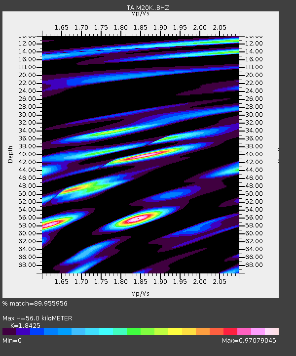
M20K Styx River, AK, USA - Earthquake Result Viewer
| Earthquake location: |
Hokkaido, Japan Region |
| Earthquake latitude/longitude: |
41.1/143.0 |
| Earthquake time(UTC): |
2019/08/28 (240) 23:46:39 GMT |
| Earthquake Depth: |
17 km |
| Earthquake Magnitude: |
6.1 Mww |
| Earthquake Catalog/Contributor: |
NEIC PDE/us |
|
| Network: |
TA USArray Transportable Network (new EarthScope stations) |
| Station: |
M20K Styx River, AK, USA |
| Lat/Lon: |
61.88 N/153.13 W |
| Elevation: |
1107 m |
|
| Distance: |
42.8 deg |
| Az: |
38.787 deg |
| Baz: |
271.428 deg |
| Ray Param: |
0.07295914 |
| Estimated Moho Depth: |
56.0 km |
| Estimated Crust Vp/Vs: |
1.84 |
| Assumed Crust Vp: |
6.566 km/s |
| Estimated Crust Vs: |
3.564 km/s |
| Estimated Crust Poisson's Ratio: |
0.29 |
|
| Radial Match: |
89.955956 % |
| Radial Bump: |
400 |
| Transverse Match: |
82.345634 % |
| Transverse Bump: |
400 |
| SOD ConfigId: |
19053131 |
| Insert Time: |
2019-09-12 00:00:43.759 +0000 |
| GWidth: |
2.5 |
| Max Bumps: |
400 |
| Tol: |
0.001 |
|

Signal To Noise
| Channel | StoN | STA | LTA |
| TA:M20K: :BHZ:20190828T23:54:05.049985Z | 6.5420036 | 2.4301949E-7 | 3.714756E-8 |
| TA:M20K: :BHN:20190828T23:54:05.049985Z | 1.1039551 | 6.337059E-8 | 5.740323E-8 |
| TA:M20K: :BHE:20190828T23:54:05.049985Z | 3.9828134 | 1.630226E-7 | 4.093152E-8 |
| Arrivals |
| Ps | 7.7 SECOND |
| PpPs | 23 SECOND |
| PsPs/PpSs | 30 SECOND |


