You are here: Home > Network List > TA - USArray Transportable Network (new EarthScope stations) Stations List
> Station Q20K Shuyak Island, AK, USA > Earthquake Result Viewer
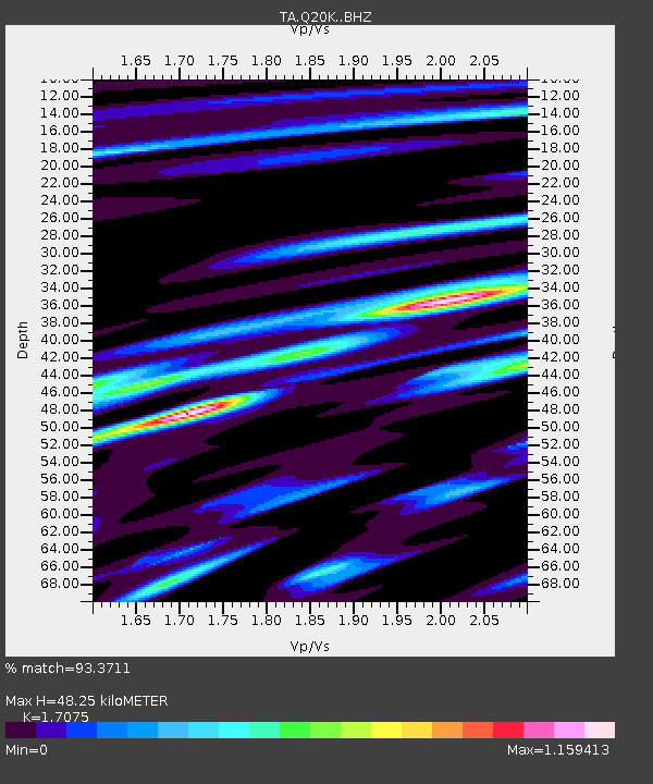
Q20K Shuyak Island, AK, USA - Earthquake Result Viewer
| Earthquake location: |
Hokkaido, Japan Region |
| Earthquake latitude/longitude: |
41.1/143.0 |
| Earthquake time(UTC): |
2019/08/28 (240) 23:46:39 GMT |
| Earthquake Depth: |
17 km |
| Earthquake Magnitude: |
6.1 Mww |
| Earthquake Catalog/Contributor: |
NEIC PDE/us |
|
| Network: |
TA USArray Transportable Network (new EarthScope stations) |
| Station: |
Q20K Shuyak Island, AK, USA |
| Lat/Lon: |
58.61 N/152.39 W |
| Elevation: |
180 m |
|
| Distance: |
43.3 deg |
| Az: |
43.556 deg |
| Baz: |
275.553 deg |
| Ray Param: |
0.07259929 |
| Estimated Moho Depth: |
48.25 km |
| Estimated Crust Vp/Vs: |
1.71 |
| Assumed Crust Vp: |
5.989 km/s |
| Estimated Crust Vs: |
3.508 km/s |
| Estimated Crust Poisson's Ratio: |
0.24 |
|
| Radial Match: |
93.3711 % |
| Radial Bump: |
286 |
| Transverse Match: |
88.72782 % |
| Transverse Bump: |
400 |
| SOD ConfigId: |
19053131 |
| Insert Time: |
2019-09-12 00:01:07.234 +0000 |
| GWidth: |
2.5 |
| Max Bumps: |
400 |
| Tol: |
0.001 |
|

Signal To Noise
| Channel | StoN | STA | LTA |
| TA:Q20K: :BHZ:20190828T23:54:09.649991Z | 4.112536 | 5.2465606E-7 | 1.2757482E-7 |
| TA:Q20K: :BHN:20190828T23:54:09.649991Z | 0.87212443 | 1.195864E-7 | 1.371208E-7 |
| TA:Q20K: :BHE:20190828T23:54:09.649991Z | 4.1821027 | 4.3655737E-7 | 1.0438705E-7 |
| Arrivals |
| Ps | 6.0 SECOND |
| PpPs | 21 SECOND |
| PsPs/PpSs | 27 SECOND |


