You are here: Home > Network List > TA - USArray Transportable Network (new EarthScope stations) Stations List
> Station R32K Eaglecrest, AK, USA > Earthquake Result Viewer
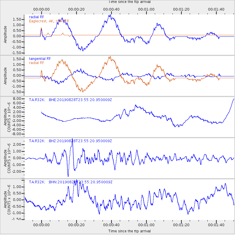
R32K Eaglecrest, AK, USA - Earthquake Result Viewer
*The percent match for this event was below the threshold and hence no stack was calculated.
| Earthquake location: |
Hokkaido, Japan Region |
| Earthquake latitude/longitude: |
41.1/143.0 |
| Earthquake time(UTC): |
2019/08/28 (240) 23:46:39 GMT |
| Earthquake Depth: |
17 km |
| Earthquake Magnitude: |
6.1 Mww |
| Earthquake Catalog/Contributor: |
NEIC PDE/us |
|
| Network: |
TA USArray Transportable Network (new EarthScope stations) |
| Station: |
R32K Eaglecrest, AK, USA |
| Lat/Lon: |
58.27 N/134.52 W |
| Elevation: |
386 m |
|
| Distance: |
52.6 deg |
| Az: |
41.283 deg |
| Baz: |
289.264 deg |
| Ray Param: |
$rayparam |
*The percent match for this event was below the threshold and hence was not used in the summary stack. |
|
| Radial Match: |
26.133482 % |
| Radial Bump: |
400 |
| Transverse Match: |
19.08174 % |
| Transverse Bump: |
400 |
| SOD ConfigId: |
19053131 |
| Insert Time: |
2019-09-12 00:01:09.993 +0000 |
| GWidth: |
2.5 |
| Max Bumps: |
400 |
| Tol: |
0.001 |
|
Signal To Noise
| Channel | StoN | STA | LTA |
| TA:R32K: :BHZ:20190828T23:55:20.950009Z | 4.4375906 | 2.6214832E-7 | 5.9074477E-8 |
| TA:R32K: :BHN:20190828T23:55:20.950009Z | 4.182735 | 7.744822E-7 | 1.8516167E-7 |
| TA:R32K: :BHE:20190828T23:55:20.950009Z | 0.73325855 | 7.019543E-7 | 9.573081E-7 |
| Arrivals |
| Ps | |
| PpPs | |
| PsPs/PpSs | |


