You are here: Home > Network List > TS - TERRAscope (Southern California Seismic Network) Stations List
> Station MLAC Mammoth Lakes, California, USA > Earthquake Result Viewer
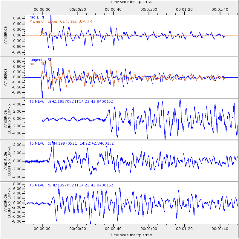
MLAC Mammoth Lakes, California, USA - Earthquake Result Viewer
*The percent match for this event was below the threshold and hence no stack was calculated.
| Earthquake location: |
Vanuatu Islands |
| Earthquake latitude/longitude: |
-20.4/169.3 |
| Earthquake time(UTC): |
1997/05/21 (141) 14:10:26 GMT |
| Earthquake Depth: |
57 km |
| Earthquake Magnitude: |
5.9 MB, 6.5 MS, 6.7 UNKNOWN, 6.1 ME |
| Earthquake Catalog/Contributor: |
WHDF/NEIC |
|
| Network: |
TS TERRAscope (Southern California Seismic Network) |
| Station: |
MLAC Mammoth Lakes, California, USA |
| Lat/Lon: |
37.63 N/118.83 W |
| Elevation: |
2170 m |
|
| Distance: |
88.8 deg |
| Az: |
49.001 deg |
| Baz: |
243.061 deg |
| Ray Param: |
$rayparam |
*The percent match for this event was below the threshold and hence was not used in the summary stack. |
|
| Radial Match: |
82.377266 % |
| Radial Bump: |
400 |
| Transverse Match: |
69.03196 % |
| Transverse Bump: |
400 |
| SOD ConfigId: |
4480 |
| Insert Time: |
2010-02-26 14:27:18.930 +0000 |
| GWidth: |
2.5 |
| Max Bumps: |
400 |
| Tol: |
0.001 |
|
Signal To Noise
| Channel | StoN | STA | LTA |
| TS:MLAC: :BHN:19970521T14:22:42.840015Z | 3.9924736 | 4.935755E-7 | 1.2362649E-7 |
| TS:MLAC: :BHE:19970521T14:22:42.840015Z | 1.4309187 | 3.0772978E-7 | 2.150575E-7 |
| TS:MLAC: :BHZ:19970521T14:22:42.840015Z | 0.7362293 | 2.0009858E-7 | 2.717884E-7 |
| Arrivals |
| Ps | |
| PpPs | |
| PsPs/PpSs | |


