You are here: Home > Network List > TJ - Tajikistan National Seismic Network Stations List
> Station GARM Garm, Tajikistan > Earthquake Result Viewer
GARM Garm, Tajikistan - Earthquake Result Viewer
| Earthquake location: |
Hokkaido, Japan Region |
| Earthquake latitude/longitude: |
41.1/143.0 |
| Earthquake time(UTC): |
2019/08/28 (240) 23:46:39 GMT |
| Earthquake Depth: |
17 km |
| Earthquake Magnitude: |
6.1 Mww |
| Earthquake Catalog/Contributor: |
NEIC PDE/us |
|
| Network: |
TJ Tajikistan National Seismic Network |
| Station: |
GARM Garm, Tajikistan |
| Lat/Lon: |
39.00 N/70.32 E |
| Elevation: |
1305 m |
|
| Distance: |
54.2 deg |
| Az: |
293.406 deg |
| Baz: |
62.928 deg |
| Ray Param: |
0.06561108 |
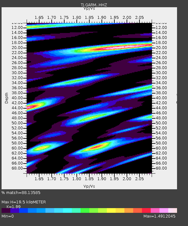
| Estimated Moho Depth: |
19.5 km |
| Estimated Crust Vp/Vs: |
1.99 |
| Assumed Crust Vp: |
6.306 km/s |
| Estimated Crust Vs: |
3.169 km/s |
| Estimated Crust Poisson's Ratio: |
0.33 |
|
| Radial Match: |
88.13585 % |
| Radial Bump: |
400 |
| Transverse Match: |
85.22 % |
| Transverse Bump: |
400 |
| SOD ConfigId: |
19053131 |
| Insert Time: |
2019-09-12 00:01:21.622 +0000 |
| GWidth: |
2.5 |
| Max Bumps: |
400 |
| Tol: |
0.001 |
|

Signal To Noise
| Channel | StoN | STA | LTA |
| TJ:GARM: :HHZ:20190828T23:55:32.590024Z | 32.84753 | 3.0025524E-6 | 9.140878E-8 |
| TJ:GARM: :HHN:20190828T23:55:32.590024Z | 12.000579 | 9.762923E-7 | 8.135377E-8 |
| TJ:GARM: :HHE:20190828T23:55:32.590024Z | 15.106006 | 1.4675143E-6 | 9.714773E-8 |
| Arrivals |
| Ps | 3.2 SECOND |
| PpPs | 8.8 SECOND |
| PsPs/PpSs | 12 SECOND |


