You are here: Home > Network List > TX - Texas Seismological Network Stations List
> Station WTFS Witchita Falls > Earthquake Result Viewer
WTFS Witchita Falls - Earthquake Result Viewer
| Earthquake location: |
Hokkaido, Japan Region |
| Earthquake latitude/longitude: |
41.1/143.0 |
| Earthquake time(UTC): |
2019/08/28 (240) 23:46:39 GMT |
| Earthquake Depth: |
17 km |
| Earthquake Magnitude: |
6.1 Mww |
| Earthquake Catalog/Contributor: |
NEIC PDE/us |
|
| Network: |
TX Texas Seismological Network |
| Station: |
WTFS Witchita Falls |
| Lat/Lon: |
33.77 N/98.46 W |
| Elevation: |
277 m |
|
| Distance: |
86.5 deg |
| Az: |
47.151 deg |
| Baz: |
318.288 deg |
| Ray Param: |
0.043999586 |
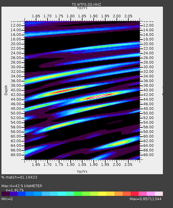
| Estimated Moho Depth: |
42.5 km |
| Estimated Crust Vp/Vs: |
1.92 |
| Assumed Crust Vp: |
6.426 km/s |
| Estimated Crust Vs: |
3.351 km/s |
| Estimated Crust Poisson's Ratio: |
0.31 |
|
| Radial Match: |
81.18423 % |
| Radial Bump: |
400 |
| Transverse Match: |
77.81099 % |
| Transverse Bump: |
346 |
| SOD ConfigId: |
19053131 |
| Insert Time: |
2019-09-12 00:01:55.129 +0000 |
| GWidth: |
2.5 |
| Max Bumps: |
400 |
| Tol: |
0.001 |
|

Signal To Noise
| Channel | StoN | STA | LTA |
| TX:WTFS:00:HHZ:20190828T23:58:49.695004Z | 4.176668 | 3.308111E-7 | 7.920455E-8 |
| TX:WTFS:00:HH1:20190828T23:58:49.695004Z | 0.840903 | 9.30673E-8 | 1.1067543E-7 |
| TX:WTFS:00:HH2:20190828T23:58:49.695004Z | 1.1099037 | 7.913744E-8 | 7.130119E-8 |
| Arrivals |
| Ps | 6.2 SECOND |
| PpPs | 19 SECOND |
| PsPs/PpSs | 25 SECOND |


