You are here: Home > Network List > US - United States National Seismic Network Stations List
> Station DGMT Dagmar, Montana, USA > Earthquake Result Viewer
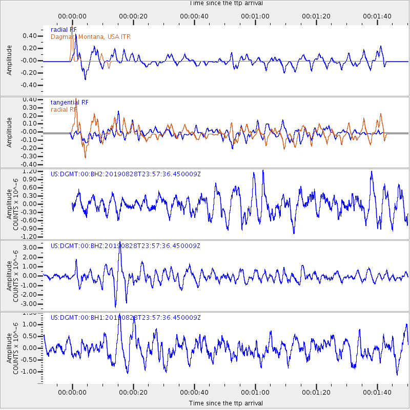
DGMT Dagmar, Montana, USA - Earthquake Result Viewer
*The percent match for this event was below the threshold and hence no stack was calculated.
| Earthquake location: |
Hokkaido, Japan Region |
| Earthquake latitude/longitude: |
41.1/143.0 |
| Earthquake time(UTC): |
2019/08/28 (240) 23:46:39 GMT |
| Earthquake Depth: |
17 km |
| Earthquake Magnitude: |
6.1 Mww |
| Earthquake Catalog/Contributor: |
NEIC PDE/us |
|
| Network: |
US United States National Seismic Network |
| Station: |
DGMT Dagmar, Montana, USA |
| Lat/Lon: |
48.47 N/104.20 W |
| Elevation: |
0.0 m |
|
| Distance: |
72.9 deg |
| Az: |
39.918 deg |
| Baz: |
313.198 deg |
| Ray Param: |
$rayparam |
*The percent match for this event was below the threshold and hence was not used in the summary stack. |
|
| Radial Match: |
74.92482 % |
| Radial Bump: |
400 |
| Transverse Match: |
62.764114 % |
| Transverse Bump: |
400 |
| SOD ConfigId: |
19053131 |
| Insert Time: |
2019-09-12 00:02:15.221 +0000 |
| GWidth: |
2.5 |
| Max Bumps: |
400 |
| Tol: |
0.001 |
|
Signal To Noise
| Channel | StoN | STA | LTA |
| US:DGMT:00:BHZ:20190828T23:57:36.450009Z | 4.5623155 | 6.394091E-7 | 1.4015012E-7 |
| US:DGMT:00:BH1:20190828T23:57:36.450009Z | 0.79409456 | 2.4648043E-7 | 3.1039175E-7 |
| US:DGMT:00:BH2:20190828T23:57:36.450009Z | 1.136192 | 2.4349632E-7 | 2.1430913E-7 |
| Arrivals |
| Ps | |
| PpPs | |
| PsPs/PpSs | |


