You are here: Home > Network List > TA - USArray Transportable Network (new EarthScope stations) Stations List
> Station T21A Navajo Lake, Ignacio, CO, USA > Earthquake Result Viewer
T21A Navajo Lake, Ignacio, CO, USA - Earthquake Result Viewer
| Earthquake location: |
South Of Panama |
| Earthquake latitude/longitude: |
5.0/-82.7 |
| Earthquake time(UTC): |
2008/06/17 (169) 17:42:09 GMT |
| Earthquake Depth: |
10 km |
| Earthquake Magnitude: |
5.6 MB, 5.3 MS, 5.9 MW, 5.9 MW |
| Earthquake Catalog/Contributor: |
WHDF/NEIC |
|
| Network: |
TA USArray Transportable Network (new EarthScope stations) |
| Station: |
T21A Navajo Lake, Ignacio, CO, USA |
| Lat/Lon: |
36.99 N/107.53 W |
| Elevation: |
2006 m |
|
| Distance: |
39.1 deg |
| Az: |
327.748 deg |
| Baz: |
138.394 deg |
| Ray Param: |
0.07515381 |
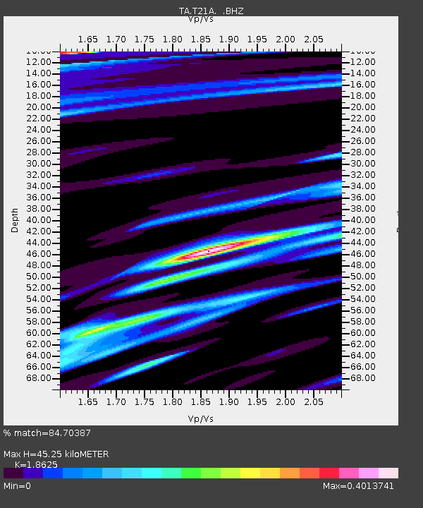
| Estimated Moho Depth: |
45.25 km |
| Estimated Crust Vp/Vs: |
1.86 |
| Assumed Crust Vp: |
6.159 km/s |
| Estimated Crust Vs: |
3.307 km/s |
| Estimated Crust Poisson's Ratio: |
0.30 |
|
| Radial Match: |
84.70387 % |
| Radial Bump: |
400 |
| Transverse Match: |
43.424953 % |
| Transverse Bump: |
400 |
| SOD ConfigId: |
2504 |
| Insert Time: |
2010-03-07 03:48:24.383 +0000 |
| GWidth: |
2.5 |
| Max Bumps: |
400 |
| Tol: |
0.001 |
|

Signal To Noise
| Channel | StoN | STA | LTA |
| TA:T21A: :BHZ:20080617T17:49:06.525011Z | 8.689362 | 8.240669E-7 | 9.4836295E-8 |
| TA:T21A: :BHN:20080617T17:49:06.525011Z | 3.6210752 | 3.0479455E-7 | 8.417239E-8 |
| TA:T21A: :BHE:20080617T17:49:06.525011Z | 1.4830831 | 1.9517155E-7 | 1.3159853E-7 |
| Arrivals |
| Ps | 6.7 SECOND |
| PpPs | 20 SECOND |
| PsPs/PpSs | 27 SECOND |


