You are here: Home > Network List > IU - Global Seismograph Network (GSN - IRIS/USGS) Stations List
> Station POHA Pohakuloa, Hawaii, USA > Earthquake Result Viewer
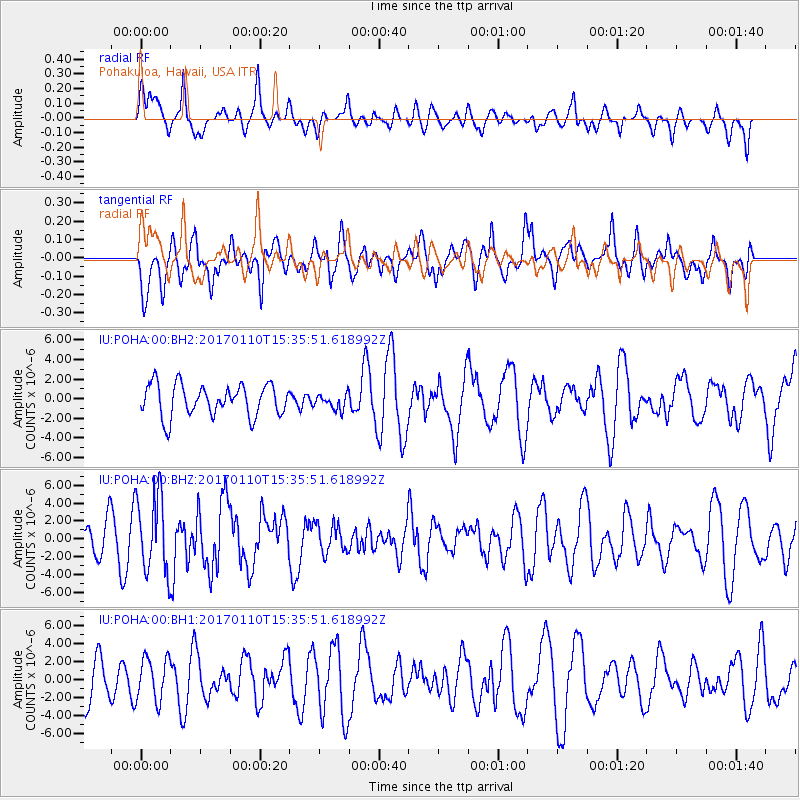
POHA Pohakuloa, Hawaii, USA - Earthquake Result Viewer
*The percent match for this event was below the threshold and hence no stack was calculated.
| Earthquake location: |
Solomon Islands |
| Earthquake latitude/longitude: |
-10.1/161.0 |
| Earthquake time(UTC): |
2017/01/10 (010) 15:27:15 GMT |
| Earthquake Depth: |
28 km |
| Earthquake Magnitude: |
6.3 Mww |
| Earthquake Catalog/Contributor: |
NEIC PDE/us |
|
| Network: |
IU Global Seismograph Network (GSN - IRIS/USGS) |
| Station: |
POHA Pohakuloa, Hawaii, USA |
| Lat/Lon: |
19.76 N/155.53 W |
| Elevation: |
1990 m |
|
| Distance: |
52.1 deg |
| Az: |
55.183 deg |
| Baz: |
239.12 deg |
| Ray Param: |
$rayparam |
*The percent match for this event was below the threshold and hence was not used in the summary stack. |
|
| Radial Match: |
58.10571 % |
| Radial Bump: |
400 |
| Transverse Match: |
57.35682 % |
| Transverse Bump: |
400 |
| SOD ConfigId: |
1943534 |
| Insert Time: |
2017-01-24 15:28:48.142 +0000 |
| GWidth: |
2.5 |
| Max Bumps: |
400 |
| Tol: |
0.001 |
|
Signal To Noise
| Channel | StoN | STA | LTA |
| IU:POHA:00:BHZ:20170110T15:35:51.618992Z | 3.6967697 | 4.3929003E-6 | 1.1883078E-6 |
| IU:POHA:00:BH1:20170110T15:35:51.618992Z | 1.0956575 | 2.3842995E-6 | 2.1761357E-6 |
| IU:POHA:00:BH2:20170110T15:35:51.618992Z | 0.48890865 | 7.876782E-7 | 1.6110947E-6 |
| Arrivals |
| Ps | |
| PpPs | |
| PsPs/PpSs | |


