You are here: Home > Network List > US - United States National Seismic Network Stations List
> Station TPNV Topopah Spring, Nevada, USA > Earthquake Result Viewer
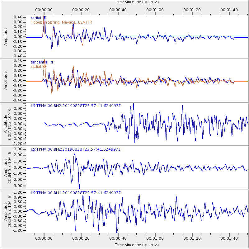
TPNV Topopah Spring, Nevada, USA - Earthquake Result Viewer

| Earthquake location: |
Hokkaido, Japan Region |
| Earthquake latitude/longitude: |
41.1/143.0 |
| Earthquake time(UTC): |
2019/08/28 (240) 23:46:39 GMT |
| Earthquake Depth: |
17 km |
| Earthquake Magnitude: |
6.1 Mww |
| Earthquake Catalog/Contributor: |
NEIC PDE/us |
|
| Network: |
US United States National Seismic Network |
| Station: |
TPNV Topopah Spring, Nevada, USA |
| Lat/Lon: |
36.95 N/116.25 W |
| Elevation: |
1600 m |
|
| Distance: |
73.8 deg |
| Az: |
55.033 deg |
| Baz: |
309.341 deg |
| Ray Param: |
0.052735813 |
| Estimated Moho Depth: |
60.5 km |
| Estimated Crust Vp/Vs: |
1.85 |
| Assumed Crust Vp: |
6.279 km/s |
| Estimated Crust Vs: |
3.389 km/s |
| Estimated Crust Poisson's Ratio: |
0.29 |
|
| Radial Match: |
90.08426 % |
| Radial Bump: |
400 |
| Transverse Match: |
82.59931 % |
| Transverse Bump: |
400 |
| SOD ConfigId: |
19053131 |
| Insert Time: |
2019-09-12 00:02:35.974 +0000 |
| GWidth: |
2.5 |
| Max Bumps: |
400 |
| Tol: |
0.001 |
|
Signal To Noise
| Channel | StoN | STA | LTA |
| US:TPNV:00:BHZ:20190828T23:57:41.624997Z | 6.568611 | 3.800574E-7 | 5.785963E-8 |
| US:TPNV:00:BH1:20190828T23:57:41.624997Z | 1.002946 | 9.2801116E-8 | 9.252852E-8 |
| US:TPNV:00:BH2:20190828T23:57:41.624997Z | 1.9583371 | 1.2587455E-7 | 6.427624E-8 |
| Arrivals |
| Ps | 8.5 SECOND |
| PpPs | 27 SECOND |
| PsPs/PpSs | 35 SECOND |


