You are here: Home > Network List > UU - University of Utah Regional Network Stations List
> Station SVWY Solvay Mine, WY, USA > Earthquake Result Viewer
SVWY Solvay Mine, WY, USA - Earthquake Result Viewer
| Earthquake location: |
Hokkaido, Japan Region |
| Earthquake latitude/longitude: |
41.1/143.0 |
| Earthquake time(UTC): |
2019/08/28 (240) 23:46:39 GMT |
| Earthquake Depth: |
17 km |
| Earthquake Magnitude: |
6.1 Mww |
| Earthquake Catalog/Contributor: |
NEIC PDE/us |
|
| Network: |
UU University of Utah Regional Network |
| Station: |
SVWY Solvay Mine, WY, USA |
| Lat/Lon: |
41.45 N/109.86 W |
| Elevation: |
1950 m |
|
| Distance: |
74.7 deg |
| Az: |
48.14 deg |
| Baz: |
311.492 deg |
| Ray Param: |
0.052152697 |
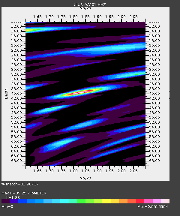
| Estimated Moho Depth: |
39.25 km |
| Estimated Crust Vp/Vs: |
1.83 |
| Assumed Crust Vp: |
6.207 km/s |
| Estimated Crust Vs: |
3.392 km/s |
| Estimated Crust Poisson's Ratio: |
0.29 |
|
| Radial Match: |
81.90737 % |
| Radial Bump: |
400 |
| Transverse Match: |
60.09476 % |
| Transverse Bump: |
400 |
| SOD ConfigId: |
19053131 |
| Insert Time: |
2019-09-12 00:02:58.911 +0000 |
| GWidth: |
2.5 |
| Max Bumps: |
400 |
| Tol: |
0.001 |
|

Signal To Noise
| Channel | StoN | STA | LTA |
| UU:SVWY:01:HHZ:20190828T23:57:46.66998Z | 5.1181192 | 1.3954784E-8 | 2.7265454E-9 |
| UU:SVWY:01:HHN:20190828T23:57:46.66998Z | 0.5365394 | 1.779496E-9 | 3.3166176E-9 |
| UU:SVWY:01:HHE:20190828T23:57:46.66998Z | 2.4229896 | 6.0399388E-9 | 2.4927629E-9 |
| Arrivals |
| Ps | 5.4 SECOND |
| PpPs | 17 SECOND |
| PsPs/PpSs | 23 SECOND |


