You are here: Home > Network List > IU - Global Seismograph Network (GSN - IRIS/USGS) Stations List
> Station XMAS Kiritimati Island, Republic of Kiribati > Earthquake Result Viewer
XMAS Kiritimati Island, Republic of Kiribati - Earthquake Result Viewer
*The percent match for this event was below the threshold and hence no stack was calculated.
| Earthquake location: |
Solomon Islands |
| Earthquake latitude/longitude: |
-10.1/161.0 |
| Earthquake time(UTC): |
2017/01/10 (010) 15:27:15 GMT |
| Earthquake Depth: |
28 km |
| Earthquake Magnitude: |
6.3 Mww |
| Earthquake Catalog/Contributor: |
NEIC PDE/us |
|
| Network: |
IU Global Seismograph Network (GSN - IRIS/USGS) |
| Station: |
XMAS Kiritimati Island, Republic of Kiribati |
| Lat/Lon: |
2.04 N/157.45 W |
| Elevation: |
20 m |
|
| Distance: |
43.1 deg |
| Az: |
75.961 deg |
| Baz: |
252.901 deg |
| Ray Param: |
$rayparam |
*The percent match for this event was below the threshold and hence was not used in the summary stack. |
|
| Radial Match: |
55.656982 % |
| Radial Bump: |
400 |
| Transverse Match: |
56.219364 % |
| Transverse Bump: |
400 |
| SOD ConfigId: |
1943534 |
| Insert Time: |
2017-01-24 15:28:59.249 +0000 |
| GWidth: |
2.5 |
| Max Bumps: |
400 |
| Tol: |
0.001 |
|
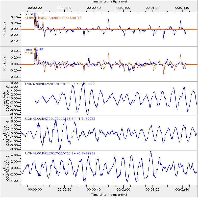
Signal To Noise
| Channel | StoN | STA | LTA |
| IU:XMAS:00:BHZ:20170110T15:34:41.843998Z | 2.255382 | 3.0431204E-6 | 1.3492704E-6 |
| IU:XMAS:00:BH1:20170110T15:34:41.843998Z | 1.1663135 | 1.6045111E-6 | 1.3757117E-6 |
| IU:XMAS:00:BH2:20170110T15:34:41.843998Z | 2.6364143 | 5.104889E-6 | 1.9363001E-6 |
| Arrivals |
| Ps | |
| PpPs | |
| PsPs/PpSs | |


