You are here: Home > Network List > UW - Pacific Northwest Regional Seismic Network Stations List
> Station LUMI Lummi Island, WA > Earthquake Result Viewer
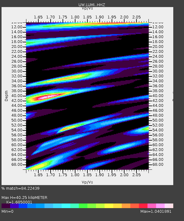
LUMI Lummi Island, WA - Earthquake Result Viewer
| Earthquake location: |
Hokkaido, Japan Region |
| Earthquake latitude/longitude: |
41.1/143.0 |
| Earthquake time(UTC): |
2019/08/28 (240) 23:46:39 GMT |
| Earthquake Depth: |
17 km |
| Earthquake Magnitude: |
6.1 Mww |
| Earthquake Catalog/Contributor: |
NEIC PDE/us |
|
| Network: |
UW Pacific Northwest Regional Seismic Network |
| Station: |
LUMI Lummi Island, WA |
| Lat/Lon: |
48.72 N/122.71 W |
| Elevation: |
19 m |
|
| Distance: |
63.1 deg |
| Az: |
47.789 deg |
| Baz: |
302.264 deg |
| Ray Param: |
0.059798304 |
| Estimated Moho Depth: |
40.25 km |
| Estimated Crust Vp/Vs: |
1.69 |
| Assumed Crust Vp: |
6.566 km/s |
| Estimated Crust Vs: |
3.897 km/s |
| Estimated Crust Poisson's Ratio: |
0.23 |
|
| Radial Match: |
84.22439 % |
| Radial Bump: |
400 |
| Transverse Match: |
83.7339 % |
| Transverse Bump: |
400 |
| SOD ConfigId: |
19053131 |
| Insert Time: |
2019-09-12 00:03:15.392 +0000 |
| GWidth: |
2.5 |
| Max Bumps: |
400 |
| Tol: |
0.001 |
|

Signal To Noise
| Channel | StoN | STA | LTA |
| UW:LUMI: :HHZ:20190828T23:56:34.609982Z | 2.5599189 | 3.0112514E-7 | 1.17630734E-7 |
| UW:LUMI: :HHN:20190828T23:56:34.609982Z | 1.1618598 | 1.4245238E-7 | 1.226072E-7 |
| UW:LUMI: :HHE:20190828T23:56:34.609982Z | 1.1556895 | 2.0610128E-7 | 1.7833621E-7 |
| Arrivals |
| Ps | 4.4 SECOND |
| PpPs | 16 SECOND |
| PsPs/PpSs | 20 SECOND |


