You are here: Home > Network List > TA - USArray Transportable Network (new EarthScope stations) Stations List
> Station T21A Navajo Lake, Ignacio, CO, USA > Earthquake Result Viewer
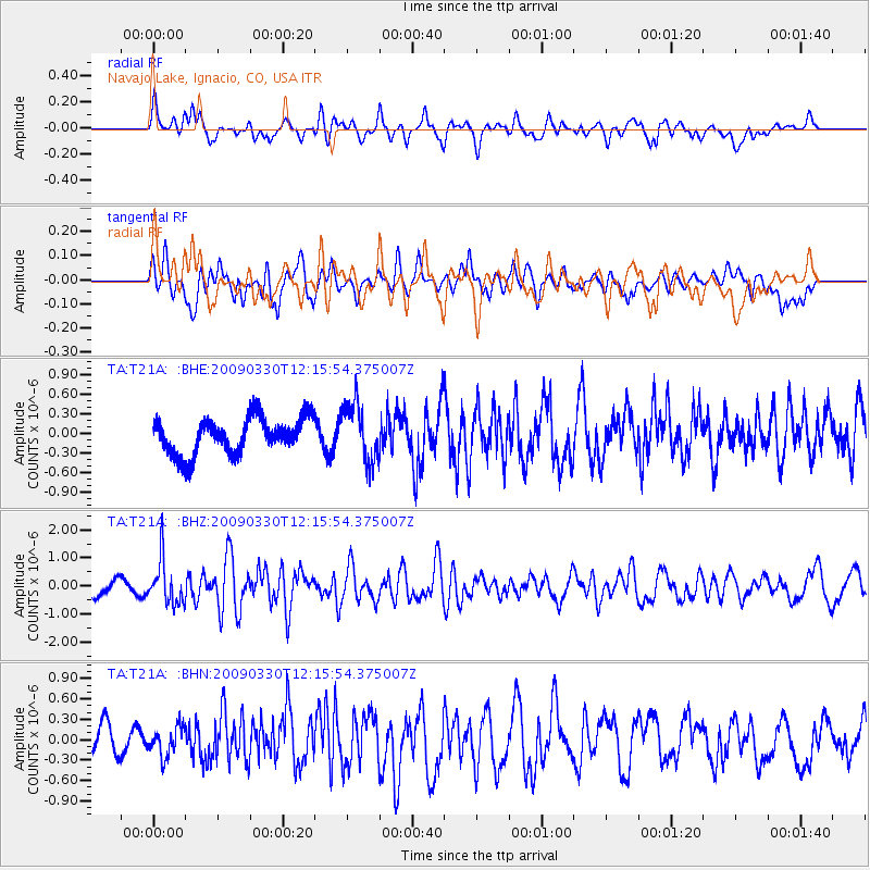
T21A Navajo Lake, Ignacio, CO, USA - Earthquake Result Viewer
*The percent match for this event was below the threshold and hence no stack was calculated.
| Earthquake location: |
Andreanof Islands, Aleutian Is. |
| Earthquake latitude/longitude: |
51.5/-178.3 |
| Earthquake time(UTC): |
2009/03/30 (089) 12:07:28 GMT |
| Earthquake Depth: |
31 km |
| Earthquake Magnitude: |
6.0 MB, 5.5 MS, 5.7 MW, 5.7 MW |
| Earthquake Catalog/Contributor: |
WHDF/NEIC |
|
| Network: |
TA USArray Transportable Network (new EarthScope stations) |
| Station: |
T21A Navajo Lake, Ignacio, CO, USA |
| Lat/Lon: |
36.99 N/107.53 W |
| Elevation: |
2006 m |
|
| Distance: |
50.7 deg |
| Az: |
77.483 deg |
| Baz: |
310.398 deg |
| Ray Param: |
$rayparam |
*The percent match for this event was below the threshold and hence was not used in the summary stack. |
|
| Radial Match: |
70.43769 % |
| Radial Bump: |
400 |
| Transverse Match: |
56.86311 % |
| Transverse Bump: |
400 |
| SOD ConfigId: |
2658 |
| Insert Time: |
2010-03-07 03:49:16.077 +0000 |
| GWidth: |
2.5 |
| Max Bumps: |
400 |
| Tol: |
0.001 |
|
Signal To Noise
| Channel | StoN | STA | LTA |
| TA:T21A: :BHZ:20090330T12:15:54.375007Z | 2.5230026 | 7.813019E-7 | 3.0967144E-7 |
| TA:T21A: :BHN:20090330T12:15:54.375007Z | 0.961146 | 2.1143298E-7 | 2.1998008E-7 |
| TA:T21A: :BHE:20090330T12:15:54.375007Z | 1.5831583 | 4.3654762E-7 | 2.7574478E-7 |
| Arrivals |
| Ps | |
| PpPs | |
| PsPs/PpSs | |


