You are here: Home > Network List > TA - USArray Transportable Network (new EarthScope stations) Stations List
> Station T21A Navajo Lake, Ignacio, CO, USA > Earthquake Result Viewer
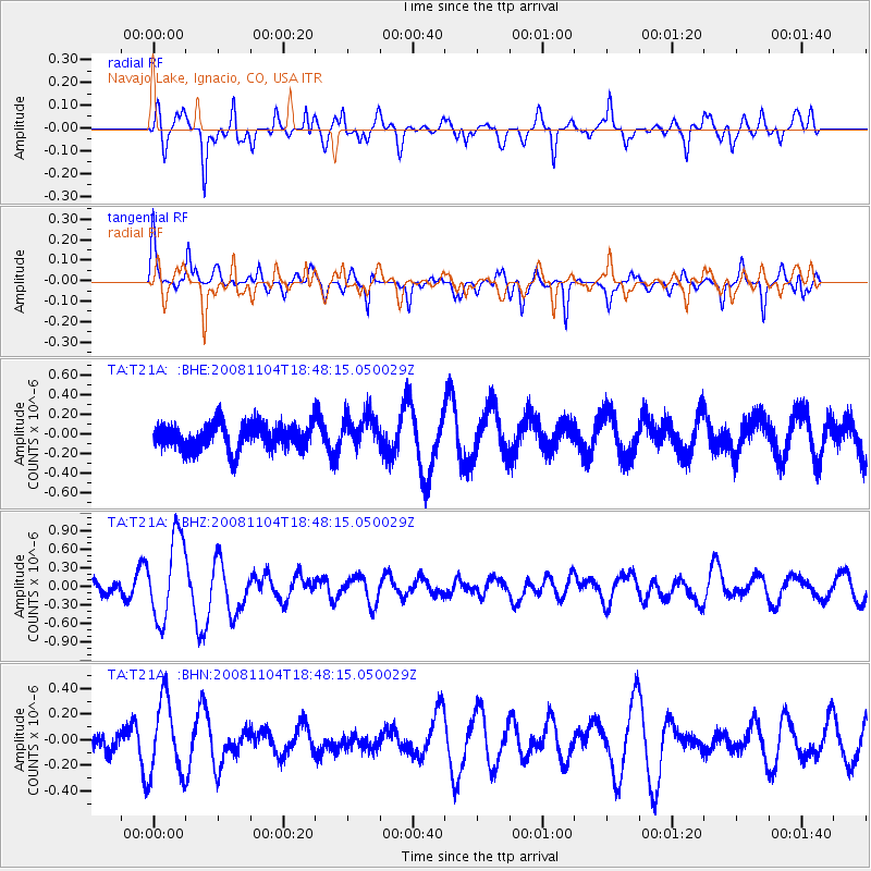
T21A Navajo Lake, Ignacio, CO, USA - Earthquake Result Viewer
*The percent match for this event was below the threshold and hence no stack was calculated.
| Earthquake location: |
Vanuatu Islands |
| Earthquake latitude/longitude: |
-17.1/168.5 |
| Earthquake time(UTC): |
2008/11/04 (309) 18:35:45 GMT |
| Earthquake Depth: |
206 km |
| Earthquake Magnitude: |
5.7 MB, 6.3 MW, 6.3 MW |
| Earthquake Catalog/Contributor: |
WHDF/NEIC |
|
| Network: |
TA USArray Transportable Network (new EarthScope stations) |
| Station: |
T21A Navajo Lake, Ignacio, CO, USA |
| Lat/Lon: |
36.99 N/107.53 W |
| Elevation: |
2006 m |
|
| Distance: |
95.5 deg |
| Az: |
53.125 deg |
| Baz: |
252.806 deg |
| Ray Param: |
$rayparam |
*The percent match for this event was below the threshold and hence was not used in the summary stack. |
|
| Radial Match: |
74.77737 % |
| Radial Bump: |
393 |
| Transverse Match: |
62.012638 % |
| Transverse Bump: |
309 |
| SOD ConfigId: |
2658 |
| Insert Time: |
2010-03-07 03:49:17.987 +0000 |
| GWidth: |
2.5 |
| Max Bumps: |
400 |
| Tol: |
0.001 |
|
Signal To Noise
| Channel | StoN | STA | LTA |
| TA:T21A: :BHZ:20081104T18:48:15.050029Z | 5.237875 | 6.7940294E-7 | 1.2970965E-7 |
| TA:T21A: :BHN:20081104T18:48:15.050029Z | 1.7423486 | 2.955763E-7 | 1.6964246E-7 |
| TA:T21A: :BHE:20081104T18:48:15.050029Z | 1.3139689 | 1.747676E-7 | 1.3300742E-7 |
| Arrivals |
| Ps | |
| PpPs | |
| PsPs/PpSs | |


